Because field data are scarce on a continental scale, we built our own ground truth by detecting management objects (e.g., mowing machinery) in high-resolution aerial imagery. The PhD work of Marcel Hudcovič github.com/HudcovicMarc...
25.01.2026 17:25
👍 1
🔁 0
💬 0
📌 0
The grassland management assessments over the Alps and Carpathians is part of the PhD work of @simonopravil.bsky.social
25.01.2026 17:25
👍 1
🔁 0
💬 1
📌 0


A great pleasure to present at the 1st WSL–Eawag Biodiversity Research Day our latest G4B (www.grass4b.com) project results: 10m resolution grassland management mapping efforts over the Alps and Carpathians. @wslbiodiversity.bsky.social @wslresearch.bsky.social @g4biodiv.bsky.social @biodiversa.eu
25.01.2026 17:25
👍 3
🔁 4
💬 2
📌 0


In the last two weeks, our G4B project (www.grass4b.com) had wide coverage (8! presentations) at two important events: the IALE 2025 European Landscape Ecology Congress and Forum Carpaticum 2025.
@euracalpenv.bsky.social @wslresearch.bsky.social @biodiversa.eu 👇
18.09.2025 08:25
👍 5
🔁 2
💬 1
📌 0
Forest matter — not just as blocks of carbon.
13.03.2025 03:17
👍 58
🔁 12
💬 0
📌 0
Berlin is a wonderful place to live—I’ve always considered it my second home. The Geography department at @humboldtuni.bsky.social is especially strong, and you can work with many AMAZING colleagues there!
06.03.2025 16:37
👍 2
🔁 1
💬 0
📌 0

Stellenausschreibungen
Hier finden Sie die laufenden Stellenausschreibungen der Personalabteilung
A bit more context on the two professorships that we are currently advertising:
- Human Geography and Global Transitions
- Geography of Global Environmental Change
haushalt-und-personal.hu-berlin.de/de/personal/...
@humboldtuni.bsky.social
03.03.2025 09:24
👍 11
🔁 4
💬 1
📌 2
Deadline abstract submission: March 14, 2025
Join us at IALE 2025 iale2025.sav.sk within two sessions closely related to our G4B project:
S3G–Interdisciplinary Responses: Perspectives for Grassland Research and Conservation Projects
S4G–Remote Sensing of the Grassland-Dominated Landscapes
03.03.2025 13:38
👍 2
🔁 2
💬 0
📌 0
It's amazing to see how much landscapes changed. In the G4B project, we strongly believe that the biodiversity of grasslands depends on the past legacies of land-use management.
We look at historical maps, satellites & aerial imagery, landscape changes 🗺️, and relate them to grassland diversity.
10.02.2025 10:53
👍 7
🔁 4
💬 0
📌 0
The Land Use Framework consultation government is launching is necessary and important. We urgently need to make strategic national decisions about what should go where: to restore ecosystems, stop urban flooding and better plan development.
31.01.2025 06:57
👍 559
🔁 83
💬 13
📌 3

The unit Land Change Science studies patterns, causes and processes of landscape change. The research group Land-Use Systems is offering a position within the DISCLOSE-project for the duration of two years (with the option for extension), starting in spring 2025, as a
PostDoc Social scientist in Digital spatial planning practice 80-100% (f/m/d)
Driven by digitalisation, spatial planning is undergoing significant change. This disruption has the potential to influence the way we plan and the way we deliver values such as equity, transparency and efficiency. The DISCLOSE project, funded with an advanced grant from the Swiss National Science Foundation (SNSF), aims to understand the effects of the digital transformation of planning in the plan-making and plan-implementation process. You will analyze how the use of digital tools by planners is changing daily land-use planning practice and develop an understanding of the rearrangements of the respective spatial and social relationship structures. In selected European cities, you will conduct ethnographic fieldwork, document analysis and interviews with local planning authorities as well as private planning consultancies. Furthermore, in collaboration with the DISCLOSE team, you will integrate the findings into an overall theoretical model of how digitalization is changing spatial planning.
You hold a PhD degree in spatial planning, urban planning or related field. Furthermore, you have strong skills in qualitative social sciences, and specifically in ethnographic methods. Knowledge of European spatial planning is an asset. A good publication record with respect to your career stage and a strong interest in the digitalization of planning complete your profile. A good command of English (spoken and written) is required, and knowledge of German and other European languages would be an advantage. You are interested in theory development and motivated to work in an interdisciplinary and international working environment.
#PostDoc Alert! Our #Land #Change #Science Unit is looking for three #Social #Scientists in #Digital #Spatial #Planning. 1/3 focus on planning practice. More info: apply.refline.ch/273855/1702/... #ScienceJobs
27.01.2025 12:13
👍 5
🔁 1
💬 0
📌 0

🚴♂️Ideme nato 🚴♀️
www.copoprad.sk/podujatie/ki...
28.01.2025 15:03
👍 1
🔁 0
💬 0
📌 0
Speaking about the grassland diversity, how it really looks like? This timelapse gives some insights from a hotspot in the Carpathians. (author V. Sifra). Few more timelapses at our G4B project website: www.grass4b.com @wslresearch.bsky.social @biodiversaplus.bsky.social
24.01.2025 10:14
👍 9
🔁 4
💬 0
📌 0


Productive discussions on G4B grassland habitat and diversity remote sensing and protection with our partners at Humboldt University today. #G4B @g4biodiv.bsky.social @wslresearch.bsky.social @biodiversaplus.bsky.social @tkuemmerle.bsky.social
21.01.2025 19:28
👍 6
🔁 7
💬 0
📌 0
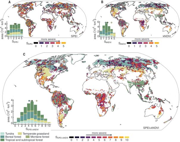
The map shows 500 of those events that happend over the last 40 years.
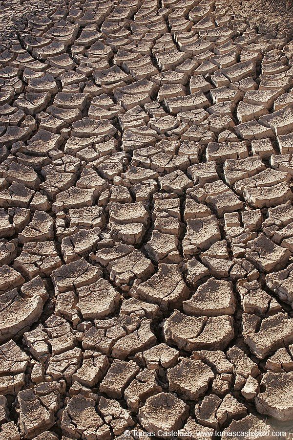
🌍 Mega-droughts are becoming more frequent and intense globally. Our study in Science www.science.org/doi/10.1126/... shows that multi-year droughts have significantly increased over the last 40 years with severe impacts @wslresearch.bsky.social @wsl-dme.bsky.social @extremeswsl.bsky.social (1/7) 🧵
17.01.2025 13:35
👍 71
🔁 32
💬 4
📌 1

CHF 1.5 million for research into digitalisation in spatial planning
A WSL researcher was awarded CHF 1.5 million from the SNSF to study how digitalisation is changing spatial planning.
How is digitalisation changing spatial planning? WSL researcher Anna Hersperger has been awarded an SNSF Advanced Grant of CHF 1.5 million to investigate this. www.wsl.ch/en/news/chf-... @snf-ch.bsky.social
16.01.2025 07:20
👍 3
🔁 1
💬 0
📌 0


