
Jupyter to Marimo?
25.02.2026 13:03
👍 1
🔁 0
💬 1
📌 0
Jupyter to Marimo?

Reminder: Join us today for the NITheCS Colloquium — “Turning Data into Decisions by Bridging Mathematics, Ecology & Policy” with Dr Sandra MacFadyen (SU).
🕓 Today, 16h00–17h00 SAST
📍 Attend in person or online
buff.ly/GPtVsp2
#Biodiversity #EcologicalResearch #Conservation #Ecology #Mathematics

Not a successor but integrating uv to resolve pypi packages. Pixi is btw developed by the dev team behind mamba, which was a huge performance improvement of conda some years ago. Here is another article that highlights some benefits of pixi: prefix.dev/blog/pixi_a_...

🍦 or 🎄?

Come by poster stand L20 today at #LPS25. Happy to chat about #savanna ecosystems, vegetation structure, #GEDI #lidar, #Sentinel-1 and whatever else you have in mind!

The first #ESA #BIOMASS image was revealed at #LPS25 yesterday. You can find a few more images (like the one attached showing desert structures in Chad) as well as additional information in this article:
www.esa.int/Applications...
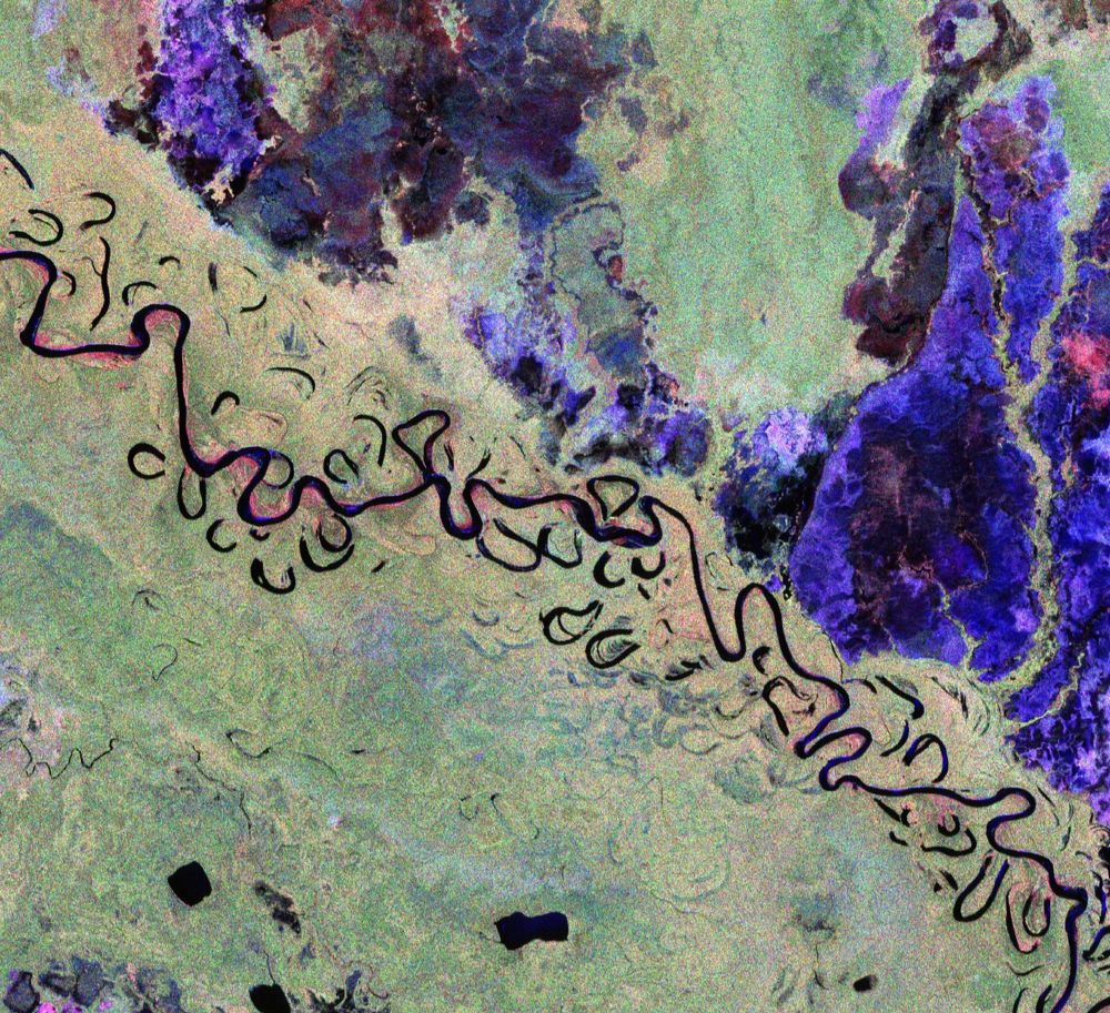
This image features part of Bolivia. This vibrant image was created using the radar instrument’s different polarisation channels, with each colour revealing distinct characteristics of the landscape. For instance, green hues mainly represent rainforest, red hues forested floodplains and wetlands, and blue–purple is indicative of grasslands, while black areas are rivers and lakes. The image spans approximately 90 km along the Biomass satellite's flight path (length) and 60 km across in width, with north oriented to the right.
🆕 The first stunning images from our groundbreaking #Biomass satellite mission have been released – they mark a major leap forward in our ability to understand how Earth’s forests are changing and exactly how they contribute to the global carbon cycle 🌳🌍
www.esa.int/Applications...
Gh is perfect for pet projects 😉
Neat! Is the project on GitHub?


The 14 March NITheCS Micro-School titled ‘Introduction to Xarray: Empowering Multidimensional Data Analysis’ by Marco Wolsza (Friedrich Schiller University Jena, Germany) may now be viewed online at buff.ly/jLJ4KKI.

I am excited to announce that Remote Sensing of Forests Summer School registration is open! Details and program: earthbridge.eu/summer-school/. See you there!
🌲🌳🛰️🛩️🚀🌍🎓
#HorizonEU #EarthObservation #Copernicus #ForestMapping
Happy to give a short coffee break introduction to Xarray this Friday!

The San Joaquin valley (dark blue area) has been sinking for quite some time: www.usgs.gov/media/images...

How depressing: 250 companies causing 73% of Ecosystem Damage globally #BIOSPACE25 @esa.int
Per their request, we decided to go for it. I changed the title to "The strain on antioxidant publishing" and did a bunch of ctrl find+replace for words like "publisher" with "gut niche" and just sent it back.
Find the paper here:
direct.mit.edu/qss/article/...
1/3
The irony of reading this while attending a conference about bio********* from space #biospace25
#eochat

Some more good news for the Sentinel-2 mission!
Sentinel-2A, which recently retired, has been given a temporary extension, where it will support S2B and S2C to provide additional data.
Lots of hard work behind the scenes to make this happen. Glad to see it!
sentinels.copernicus.eu/web/sentinel...
"Tropical and subtropical grasslands and savannas matter for biodiversity protection, and the future of this planet relies on these ecosystems to the same extent it relies on forests." 💚
📌
How about pixi.sh ?
Looks more like a Vonoroi mosh pit to me.

First image taken by ESA Sentinel-1 C SAR radar over the svalbard /spitzberg.
It was time ! S1A is in end of life and S1B is dead.
The avantage of SAR is that it doesn't care if it is day or night or if there are clouds.

A new #Sentinel-1 satellite has already been launched in our office today and is now in orbit around the Christmas tree. Hopefully the Sentinel-1C launch is going to be just as successful tonight! 🛰️ #EarthObservation #remotesensing #EOChat #ESA #Copernicus

Figure 4 from Champreux et al. (2024, Ecological Monographs) To the right: a map of the world with shades of purple and yellow showing that the rate of agreement among terrestrial biome maps is higher in equatorial forests and tropical deserts To the left: a graph aligned with the map showing that the average agreement by latitude among biome maps is higher on the Equator and the two Tropics
🌐 Did you know?
“Desert” “rainforest” “tundra” “grassland” or “savanna” are widely used terms in common language, but each have multiple definitions and no universally accepted spatial distribution.
Find out more in our recent paper 👉 doi.org/10.1002/ecm....
#biome #ecology #biogeography
Not exclusively, but I guess it depends on the topic of interest. It's possible to search for keywords (e.g., "drones", "airborne") in session titles and abstracts. Maybe you'll find one that fits you.
Abstract submission deadline for ESA Living Planet Symposium #LPS25 has been extended to December 3rd!
lps25.esa.int
#EOChat #EarthObservation


New work, where I went into human computer mode to translate a NOAA satellite image I received via radio frequency into a tonal drawing, pixel by pixel.