FOSS4G Auckland 2025
FOSS4G stands for Free and Open Source Software for Geospatial, a conference hosted in partnership with OSGeo.
Hey #gischat - you've got just 24 hours left to submit a talk or get early bird pricing for @foss4g.org - it won't be extended again! Community voting will start on over 200 talks and 40 workshop proposals from next week. 2025.foss4g.org
17.07.2025 09:20
👍 5
🔁 4
💬 1
📌 0
The best time to lock in your FOSS4G 2025 registration is this week!!
#osgeo #foss4g #gischat
24.06.2025 10:00
👍 5
🔁 1
💬 0
📌 0

Are you on the @foss4g.org mailing list? If not, you just missed the most important email of the year! Registration is now open. Also the call for papers, community vote for the logo, the travel grant program and... we're excited!
Check the mailout below, and subscribe!
mailchi.mp/foss4g/foss4...
31.03.2025 05:52
👍 4
🔁 4
💬 0
📌 0

FOSS4G Mailing List Landing Page
Hey! There's a FOSS4G 2025 mailing list to sign up to: mailchi.mp/foss4g/maili...
And the logo competition is live: 2025.foss4g.org/logo-competi...! Win a conference registration + more!
#gischat #foss4g #osgeo
26.02.2025 20:03
👍 6
🔁 5
💬 0
📌 1
This. And I have near-whole-country-coverage of LiDAR open data at my fingertips... #gischat
26.02.2025 20:00
👍 3
🔁 0
💬 0
📌 0
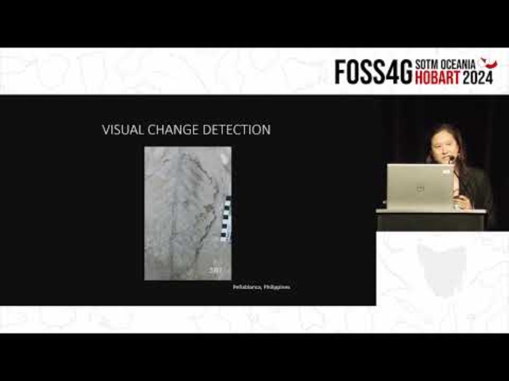
Andrea Jalandoni - Machine learning applications for rock art research
YouTube video by FOSS4G SotM Oceania
Sharing my favourite recording from FOSS4G SotM Oceania in Hobart late last year. Such a cool keynote from Andrea Jalandoni on the application of photogrammetry, lidar, hillshades, false colour imagery etc for rock art research.
youtu.be/YJfrPuUuJ4A?...
29.01.2025 21:59
👍 3
🔁 1
💬 0
📌 0
Andrea Jalandoni - Machine learning applications for rock art research
YouTube video by FOSS4G SotM Oceania
Using photogrammetry, lidar, hillshades and false colour imagery to better visualise rock art!
www.youtube.com/watch?v=YJfr...
29.01.2025 19:53
👍 1
🔁 0
💬 1
📌 0

Image of the US Embassy building in Vanuatu prior to the M 7.3 earthquake that caused the first storey to collapse.
Before for comparison.
18.12.2024 08:11
👍 5
🔁 0
💬 0
📌 0

Screenshot of job listing

Screenshot of job listing
An exciting job opening in our Geoscience Australia #DigitalEarthAU program: a Director role developing and managing the high-performance ICT systems and data pipelines that power our continental-scale #EarthObservation and #geospatial data science! 🛰️🌏👩💻
www.apsjobs.gov.au/s/job-detail...
16.12.2024 03:40
👍 20
🔁 12
💬 1
📌 1
Rosy Tin Teacaddy: Overland
YouTube video by RosyTinTeacaddy
Was at a small concert in a small town one night and the opening act said "this one's for all the geographers out there" and started singing about latitudes and contours: www.youtube.com/watch?v=6Zbi...
#gischat
16.12.2024 03:03
👍 2
🔁 0
💬 0
📌 0
Very cool!!
08.12.2024 08:14
👍 0
🔁 0
💬 0
📌 0
Stunning.. is it a series of layered elevation cross sections with ON1 providing some AI-generated clouds for good measure? What's the vertical exaggeration?
08.12.2024 07:45
👍 0
🔁 0
💬 1
📌 0
Open source software users: what would help you feel comfortable contributing to documentation for a project? What do you need to know? What are your roadblocks? Does any particular project do a good job of cultivating or welcoming documentation contributors? #gischat
06.12.2024 18:44
👍 18
🔁 6
💬 4
📌 0
(5/5) With this sponsorship, we hope to increase the sustainability of the GDAL project and ensure its continued success. Huge thanks to all of the code maintainers, contributors, sponsors and the team at @numfocus.bsky.social!
06.12.2024 04:18
👍 2
🔁 0
💬 0
📌 0
(4/5) Over this past decade or so, we have funded a number of improvements to the GeoTIFF, GeoPackage, SQLite, FileGDB, PostgreSQL and CSV drivers, recognising the critical role GDAL/OGR plays in ensuring interoperability in the geospatial software ecosystem.
06.12.2024 04:16
👍 3
🔁 0
💬 1
📌 0
(3/5) In 2019, we funded the creation of the Cloud Optimised GeoTIFF driver. A lot of groundwork had been funded by other orgs, but the driver wrapped it all up in a bow, reducing the number of commands to run and flags to set to get a nice default COG output.
06.12.2024 04:16
👍 2
🔁 0
💬 1
📌 0
(2/5) We have been using GDAL since the mid 2000s, directly funding features since ~2015, and in 2018 we were the third largest funding contributor to the GDAL Barn Raising (gdalbarn.com). Each year we run millions of GDAL commands to ensure our data holdings are standardised in open formats.
06.12.2024 04:15
👍 3
🔁 0
💬 1
📌 0
(1/5) My employer, Toitū Te Whenua Land Information New Zealand (linz.govt.nz) is now sponsoring GDAL (gdal.org/en/latest/sp...).
I believe we are the first government mapping agency to directly sponsor the project. Would be great to have some peers join us!
#osgeo #foss4g #gdal #gischat
06.12.2024 04:14
👍 37
🔁 9
💬 2
📌 0
#gischat !
05.12.2024 18:49
👍 7
🔁 2
💬 0
📌 0
Then we have STAC Items which are also GeoJSONs and STAC Collections which are not GeoJSONs
04.12.2024 02:14
👍 0
🔁 0
💬 1
📌 0
geo-robots.txt to tell the robots what your .jsons contain 😅 In your specific case can you ask what you should expect to find?
04.12.2024 01:54
👍 0
🔁 0
💬 1
📌 0
Exactly! Lower barriers to entry + great examples should be something to aim for year-on-year. 😇
03.12.2024 23:07
👍 0
🔁 0
💬 0
📌 0
Oof I am terrible at naming things but I like all of these! Keen on the open in #OpenDataCountdown!
03.12.2024 22:57
👍 1
🔁 0
💬 0
📌 0
Data catalogs are cool and all but many of our orgs have thousands of datasets in them and an annual call-to-action of some kind might help to showcase the good stuff?
03.12.2024 21:30
👍 2
🔁 0
💬 1
📌 0
@briannaritapagan.bsky.social @satellitesci.bsky.social @opencholmes.bsky.social I think we need a #30DayMapChallenge but for open data providers to promote their best work. Preferably analysis-ready / cloud-native / open-format etc. Each October leading into the map challenge?
03.12.2024 21:25
👍 13
🔁 3
💬 3
📌 0
I walk an irrationally long way to cross over that bridge rather than any of the quadrillion existing sets of lights. These proposals are just sad.
03.12.2024 21:13
👍 1
🔁 0
💬 0
📌 0
Go to the hamburger menu -> Feeds -> search for Quiet Posters
29.11.2024 08:12
👍 2
🔁 0
💬 1
📌 0

#gischat
28.11.2024 00:37
👍 36
🔁 8
💬 0
📌 1
Thanks heaps Robbi, much appreciated! Eagerly awaiting the recording of your Hobart talk so I can share with colleagues.
28.11.2024 05:31
👍 2
🔁 0
💬 0
📌 0

Map showing New Zealand coverage (more than 70% of the country) of 1m resolution LiDAR-derived elevation surfaces available as national standardised, cloud-optimised digital elevation models.

Map showing New Zealand's authoritative national imagery basemap, showing the North Island, South Island, Stewart Island and Chatham Islands with 10m resolution Sentinel-2 derived satellite imagery.
👋 Hi! I'm a geospatial product owner leading a cloud-native data engineering team in Wellington, New Zealand. We help process nationally standardised & open datasets - like aerial imagery and elevation data.
🌏 Looking forward to seeing a bunch of awesome people in Aotearoa for FOSS4G 2025!
28.11.2024 04:04
👍 33
🔁 5
💬 1
📌 0