
Image 1
University of Alaska funds tsunami detections station through January as federal funding remains uncertain 👉 https://tinyurl.com/43s4ptss
20.12.2025 05:03
👍 20
🔁 5
💬 0
📌 1
Image 1
University of Alaska funds tsunami detections station through January as federal funding remains uncertain 👉 https://tinyurl.com/43s4ptss

🌊 #EGU26 Call for Abstracts
SM3.2 | Advancing Ocean-bottom and Amphibian Geophysics: from novel instrumentation to new scientific discoveries
Invited speaker: Emilie Hooft (University of Oregon) on large-scale OBS experiments.
🕒 Deadline: 15 Jan 2026, 13:00 CET
👉 www.egu26.eu/session/55674
I was notorious for midnight before a next day flight in grad school 😬
Think I’ve set a personal record on getting an AGU poster printed today! Stop by DI13B-0037 at #AGU25 on Monday afternoon if you want to learn more about new functionality we’ve been adding to the ATaCR code for ocean bottom seismic noise analysis and removal.
Sneak preview: 🐙🐡🐳
The underwater seismometer network is so great, as evidenced from yesterday's EQ off-Tohoku.
Reposting unofficial visualization by x.com/kotoho76/sta...

Quoted supporting our counterparts and friends at the Alaska Earthquake Center. The cost of the U.S. tsunami warning and mitigation effort is really a pittance. None of it has ever been adequately funded in any administration, and now things are worse. ⚒️ www.nbcnews.com/science/tsun...

NOAA’s National Weather Service holds the federal responsibility for tsunami warnings, and has historically been a primary supporter of seismic data collection in Alaska
Hopefully we landed on something useful to people! We definitely landed on more questions for the future…..
… a lot of recent developments in seafloor technologies and imaging approaches, where traditionally more siloed techniques are overlapping in their frequencies. Overall, was a fun excuse to dive into some of the weirdnesses of OBS data that @jbrussell.bsky.social and I have pondered for years!
4. Overall there’s still a lot more work to be done to understand what exactly is happening with ambient noise wave propagation recorded on OBS at periods <10 s, what that means for the depth sensitivity of observations, and implications imaging applications. And it’s an exciting time as we have…
3. You can absolutely accidentally remove your signal from ambient noise cross correlation functions at longer periods with transfer function techniques if you’re not careful, but it’s pretty straightforward to assess if this is an issue in your dataset via SNRs.
2. Leveraging short period ambient noise measurements is a lot easier if you’re in the deep open ocean, although similar quality data is certainly possible in shallower more coastal settings.
1. Shallow structure matters, especially at shorter periods. While this has likely been obvious in some imaging communities for quite a while, passive OBS arrays are more recently using shorter periods. That helps constrain crustal structure with passive methods, but care is needed.
Josh beat me to this, but yes, we have a new paper out on how noise variability affects ambient noise imaging on ocean bottom seismic arrays. So much time spent nerding out over OBS! But it was worth it for a couple of interesting findings.
📢🌊 Funded PhD position in Marine Seismology at Syracuse University 🌊📢
I'm seeking an enthusiastic student to join our Seismology group at SU! You'll be part of a collaborative NSF-funded team to collect new marine seismic data to work out the tectonics of early seafloor spreading in the Atlantic.
The Alaska Division of Geological & Geophysical Surveys is hiring a volcanologist who would work with the Alaska Volcano Observatory. A fantastic opportunity to work with great people and study very active volcanoes. Details in link below. Applications close on Oct. 1. ⚒️🌋🧪 bit.ly/3IkqN9n

📣 SAVE THE DATE
Mark your calendars for the SZ4D Science Community Meeting in Long Beach, CA, April 20-22, 2026, preceded by an early career event. Full program, registration, travel grant applications available in the Fall. Open to all. More info -> www.sz4d.org/events/2026-...

Here is @noaa.gov's model of the tsunami propagation from the people at PMEL, initiated with the earthquake location and then calibrated by the DART buoy observations. There is a wealth of great information at their website (link in thread). (1/6) ⚒️ www.youtube.com/watch?v=oOtJ...
The ability to do this requires continued investment and improvement in monitoring instrumentation, data collection, modeling, basic scientific research, and emergency management agencies. And international collaboration and communication is essential, since tsunamis do not care about borders.
So while this time was a success, it’s absolutely not the time to become complacent. And it’s worth remembering that the 1946 tsunami spurred the creation of the Pacific Tsunami Warning Center, which today, along with other organizations, still issues warnings to communities around the Pacific.
I received first official emergency alerts about an hour after the earthquake, although I was already glued to NOAA’s tsunami website by that point. So take an hour off that travel time for people to start responding, you have 3.5-4 hrs, that 3 hours of gridlock traffic starts to not look so good.

In fact in 1946 one did, and the waves were much bigger reaching around 55 ft in places in Hawaiʻi. sos.noaa.gov/catalog/data.... While this is the largest and most destructive tsunami in modern history here, other Aleutian earthquakes have also occurred generating tsunamis.
Nice article about the tsunami response here in Hawaiʻi earlier this week. While this time the waves and impacts were minimal, it’s a reminder that isn’t always the case and we won’t always have that much time. An Aleutian earthquake can generate a tsunami that reaches Hawaiʻi in ~4.5-5 hrs.
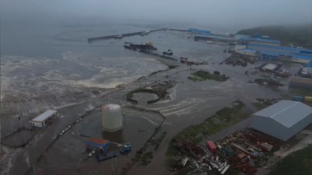
After a 25-hour workday, I'm finally home from this #tsunami response! I have many thoughts to share soon, but most of them come down to "hey, maybe we shouldn't defund the National Tsunami Hazard Mitigation Program, which funds the vast majority of state-level tsunami work in the US!"
Thank you!!

Tsunami / water level gauge experts. Any idea what this late peak at Midway is? Glitch or something real?
Another earthquake story from @sciam.bsky.social by the always-excellent @squigglyvolcano.bsky.social explaining why the tsunami from the Russia quake wasn't as huge as the one from the 2011 Japan quake, for example. 🧪

Modelling results for the #Kamchatka tsunami from July 30, 2025. Pacific ocean in dark blue, red and yellow colors show the wave heights. In grey, the land masses of Eurasia (upper left), Australia (lower left) and the Americas (right).
Fresh from the press, so to speak, a result of our #tsunami model based on the specifics of this earthquake (we will update it one we have more model runs). The color code is wave height in metres. The dotted line in the centre of the picture is the Hawaiian island chain.
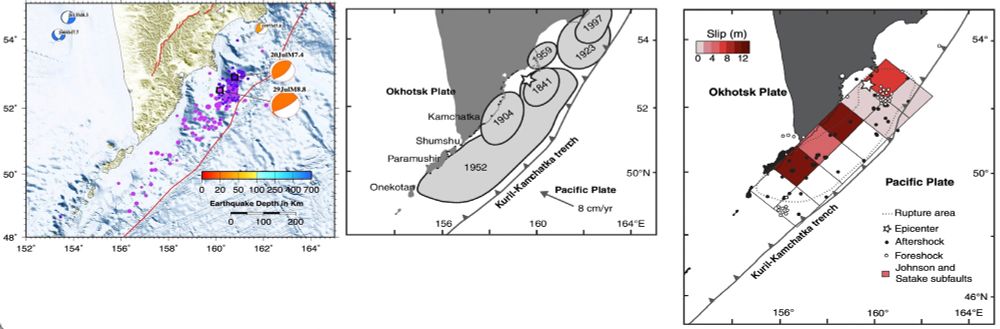
Figure from Macinnes et al. conpared to map of today’s Kamchatka earthquake by Jascha Polet.
Another quick comparison of the 1952 #Kamchatka #earthquake from MacInnes et al. (2010) with today’s M8.8 event. The aftershock areas are similar, as well as one region of foreshocks. The updated USGS rupture model has a max slip of 10m versus 12m for 1952, with SW rupture direction. 🧪⚒️
