

And by Helene (2004) I meant Helene (2024).
05.06.2025 00:41
👍 1
🔁 0
💬 0
📌 0
FYI, the two Major Hurricanes at landfall where genesis was less than 3 days prior are Alicia (1983; 100 kt landfall) and Helene (2004; 120 kt landfall).
@franklinjamesl.bsky.social I agree that the very strongest landfalling TCs tend to be weak 3-days prior (and indicative of recent RI before landfall), but on average the relationship seems to be opposite, with a positive (albeit moderate) correlation. Thanks for posing this interesting question!
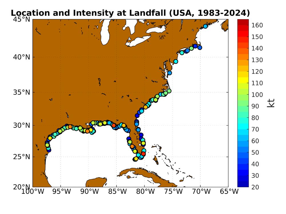
Location of U.S. landfalling TCs from 1983-2024, colored by the intensity at landfall. Data is shown regardless of landfall intensity or if there is a corresponding best track record 72-h prior to landfall. Landfalls for which there was a prior U.S. landfall within 6 h are excluded. Note that the data points are sorted by intensity prior to plotting, so that the strongest landfalling storms are on top where there is spatial overlap.

Best track intensity at landfall vs. the intensity 72-h prior to landfall, for U.S. landfalls from 1983-2024. Landfalls for which there was a prior U.S. landfall within 6 h are excluded. For each case, the synoptic time closest to landfall is identified, and the best-track intensity at the time 72-h prior is plotted vs. the intensity at the time of landfall. For the 78/192 (41%) of cases where genesis is less than 72 h prior to landfall, the "intensity" is set to 25 kt (except for the subset of 8 cases with best-track intensity data prior to genesis whose values are retained) and these data are plotted separately in red. Note that a small amount of random noise is added to all data to minimize the overlap of points with the same pair of intensity values. The 1-to-1 line is shown in black. Correlation coefficient is 0.43 when excluding cases with genesis less than 72-h prior to landfall (0.53 when including).
So @jimmy-yunge.bsky.social beat me to it (nice job Jimmy!), but I'll share my analysis anyway, which is slightly different in methodology (details in alt-text), but generally consistent in result. This shows that the higher the landfall intensity, the *higher* the intensity 72-h prior.


Looking back towards the Manhattan skyline. #NYwx 🏙️
Taking off from LGA this afternoon…


one of the better sunsets I’ve seen in a while…always nice to visit Colorado
#Sunset yesterday by Dillon Reservoir #COwx

Panoramic view (if you click on it) looking down “The Incline” near Colorado Springs. This is at step 1800 out of 2,768. We actually only climbed about 10 steps, having instead hiked up the Barr Trail to this intersection. A nice 4 mile post-Thanksgiving hike.
en.m.wikipedia.org/wiki/Manitou...


Local Monterey wildlife yesterday

Iridescence in a contrail overhead in #Monterey just before the plane disappeared behind the clouds. #CAwx

