
30.01.2026 12:58
👍 0
🔁 1
💬 0
📌 1

@timwrightleeds
Prof of Satellite Geodesy, School of Earth and Env, Univ Leeds; Director of NERC_COMET; Co-founder of SatSenseLtd; @timwright_leeds on another site; Fringes, Quakes and some other stuff. All views my own.
Thrilled that this paper is finally out. It's been a long time in the making! Thanks to all the team members who have helped make it possible.
🚨 New map redraws our understanding of how continents deform 🚨
We are excited to share ground-breaking work led by COMET Co-Director @timwrightleeds.bsky.social, published in @science.org. Read more: comet.nerc.ac.uk/new-map-redraws-our-understanding-of-how-continents-deform/
#Tectonics #Research
Watch this space. Paper now finally accepted after a long journey and data will all be available (much improved on version above as you will see in Jon’s talk below)
Following the #HayliGubbi eruption, our paper on the Erta Ale dike of Jun-Jul is finally out. InSAR, optical data and seismicity showed the temporal evolution of the intrusion and the interaction of magmatic sources, including a sill inflation in Hayli Gubbi. @earth-science.bsky.social #geoscience
Pre- and post-eruption visible imagery of #HayliGubbi from #Sentinel-2, showing tephra deposits and 2 new craters. The latter could be eruption vents and/or formed by post-eruptive subsidence. Looks like the pre-existing crater was enlarged by the eruption. @esa.int


The Hayli Gubbi tephra has been sampled. These are photos from my sampling expedition on 24 Nov with the University of Semera from around 10 km north of Hayli Gubbi @sorcerinsar.bsky.social @alarosa.bsky.social
Some nice commentary on the #HayliGubbi #eruption here from @julietbiggs.bsky.social and others. As discussed, it's unlikely that this is actually the first eruption of the volcano in 12,000 years. The Afar region is very active but also remote and understudied.
bsky.app/profile/scia...

Quite a lot of research located in and around Afar region has been presented as part of the #RiftAndRiftedMarginsSeminar series - organised by @sasbrune.bsky.social
www.youtube.com/@riftandrift...
@timwrightleeds.bsky.social @julietbiggs.bsky.social
Thanks Tim. @planet.com imagery from Nov 24 show some subsidence in the southern half of the Erta Ale caldera after the #HayliGubbi eruption (plus widespread ash deposits).
Activity at Hayli Gubbi began in July when there was an eruption at Erte Ale. Magma propagated 30 km south passing under Hayli Gubbi. Since then, there has been a small plume, quasi-continuous SO2 emissions and uplift. Details in @uk-comet.bsky.social event response report: tinyurl.com/y3nfdfj8
Co-eruptive Sentinel-1 data should be acquired tomorrow evening so we'll likely have good InSAR on Wednesday

We think there was a small eruption there in July/August (at least a small plume) and some ongoing activity there since (including continued uplift). I suspect all linked to recent activity along dyke from Erta Ale (See COMET reports on July/August activity at comet.nerc.ac.uk/event-respon...).
Early days for this one, but doesn’t look like somewhere we’d associate with magma movement.
Yes - think so. The real power in the 2005 event (actually a sequence that continued to 2010) was magma moving into a volcanic dyke. The earthquakes were largely side effects.
Yes - that event was extraordinary. Hopefully this is not!
Yes. Looks like a moderate event on the fault that bounds the Afar depression. Will check in with our colleagues at Addis Ababa University.


Day 3 of @esa.int #LPS25 in Vienna is in full flow! At 11.30am we have two talks by @timwrightleeds.bsky.social and
Camila Novoa Lizama from @envleeds.bsky.social. At 4.15pm Erin Mills @bgs.ac.uk is presenting and, after that session, there will be lots of COMET posters to see. More info below:


The sun rises early over Leeds on the longest day of the year as we set off from the train station towards Vienna for ESA’s Living Planet Symposium #lps25 🌞🌞
The coming week, I (Stijn Vleugels, Uni of Leeds) will be taking over the COMET socials to give you a firsthand experience of the conference!
Really impressive, rapid analysis of the Myanmar surface rupture video.

compound with the gates? If so then fault is more or less north-south?
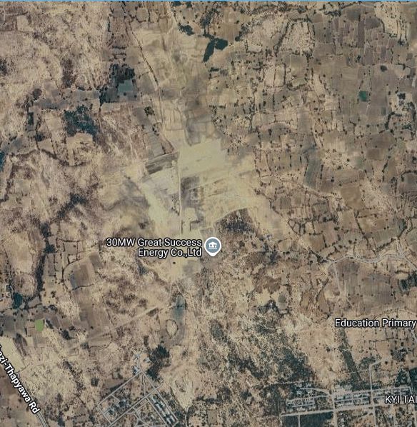

I think this is it. The dark areas in the recent Sentinel-2 imagery are the solar panels.
Maybe quite a lot of foreshortening based on aerial photo?
Seems to be in a step-over zone from the imagery. If photo is to SSW, then that would make the rupture more or less north-south though? None of the satellite/openstreet map etc have the solar farm mapped to get a robust orientation as far as I can tell.
Data posted with ~100m pixels but actual resolution a little trickier to quantify as the input data for the 3D inversion is largely Sentinel-1 pixel tracking, but also includes some burst overlap interferometry. @mrnergizci.bsky.social might comment on detailed pixel tracking parameters
The geotifs are available via the comet news article linked above.

Comments in this video have it at 20°52'55.4"N 96°02'07.0"E www.youtube.com/watch?v=77ub... . Image shows location on COMET N-S displacements from Sentinel-1. About 3 m of overall displacement, but higher-res offset data would be good to get details.

Incredible. Been waiting a long time to see a surface rupture video. The rupture is pretty simple (single strand) so I'd guess it was the primary fault comet.nerc.ac.uk/myanmar-eart... . But there looks like a small stepover near Thazi? Anyone managed to get a fix on the exact location yet?
Apparently surface rupture during the Myanmar 2025. I'm very surprised by the weak shaking along the rupture. I'm not sure if this is the main rupture (I would say no - nonetheless, VERY COOL). Author unknown, location Thazi (to be confirmed)


