Footage coming out of Union City, Michigan of the violent tornado that just hit the area.
The lake seen in this clip is frozen.
Footage provided by @WSLPIG on X.
#severewx #wxsky
06.03.2026 22:18
👍 142
🔁 70
💬 4
📌 31

#tornado last night near Bluff City, KS around 11:30pm #kswx
06.03.2026 15:34
👍 57
🔁 15
💬 0
📌 3

a tornado last night at 10:41pm just south of Wakita, Oklahoma
06.03.2026 17:06
👍 31
🔁 5
💬 0
📌 0

Generally density differences like this one do not make great chase chase days. It's bubbly and humid, but the cold air is coming and our winds just aren't SE enough for long lived supercells.
06.03.2026 20:22
👍 2
🔁 1
💬 0
📌 0

Surface weather map
The tornadic supercell in southern Michigan was right along the warm front
06.03.2026 21:25
👍 13
🔁 0
💬 2
📌 0


These storms have been riding the intersection between a differential heating boundary (dashed) and a diffuse warm front (solid). The lifting warm front keeps the storm supplied with moist inflow with little enough CINH to keep the tornado threat around.
06.03.2026 04:53
👍 15
🔁 6
💬 0
📌 0
Today is SPC's first explicit forecast of significant tornadoes possible (CIG1) in a tornado probability less than 10%. Based on radar data and environment a significant tornado may have occurred in parts of that forecast area. SPC could not have explicitly forecast this kind of scenario previously.
06.03.2026 04:54
👍 47
🔁 17
💬 1
📌 0

These tornadoes are occurring near a minimum in MLCIN, with less than 25 J/kg analyzed per mesoanalysis
06.03.2026 04:39
👍 14
🔁 0
💬 0
📌 0
After the occlusion, the first tornado dissipated east of the radar site, while a new updraft grew to the southeast, stretching vorticity along the gust front (other processes likely active as well) into a new tornado
06.03.2026 04:30
👍 16
🔁 2
💬 1
📌 0
Textbook occlusion as the rear-flank gust front surges eastward south of the tornado as the tornado deviates northward
06.03.2026 04:04
👍 32
🔁 3
💬 1
📌 0
This tornado is occluding right around the Vance AFB radar (KVNX)
06.03.2026 03:58
👍 17
🔁 7
💬 0
📌 0
Radar loop of a long lived tornado approaching the Vance Air Force Base radar site in NW Oklahoma
06.03.2026 03:44
👍 34
🔁 9
💬 0
📌 1

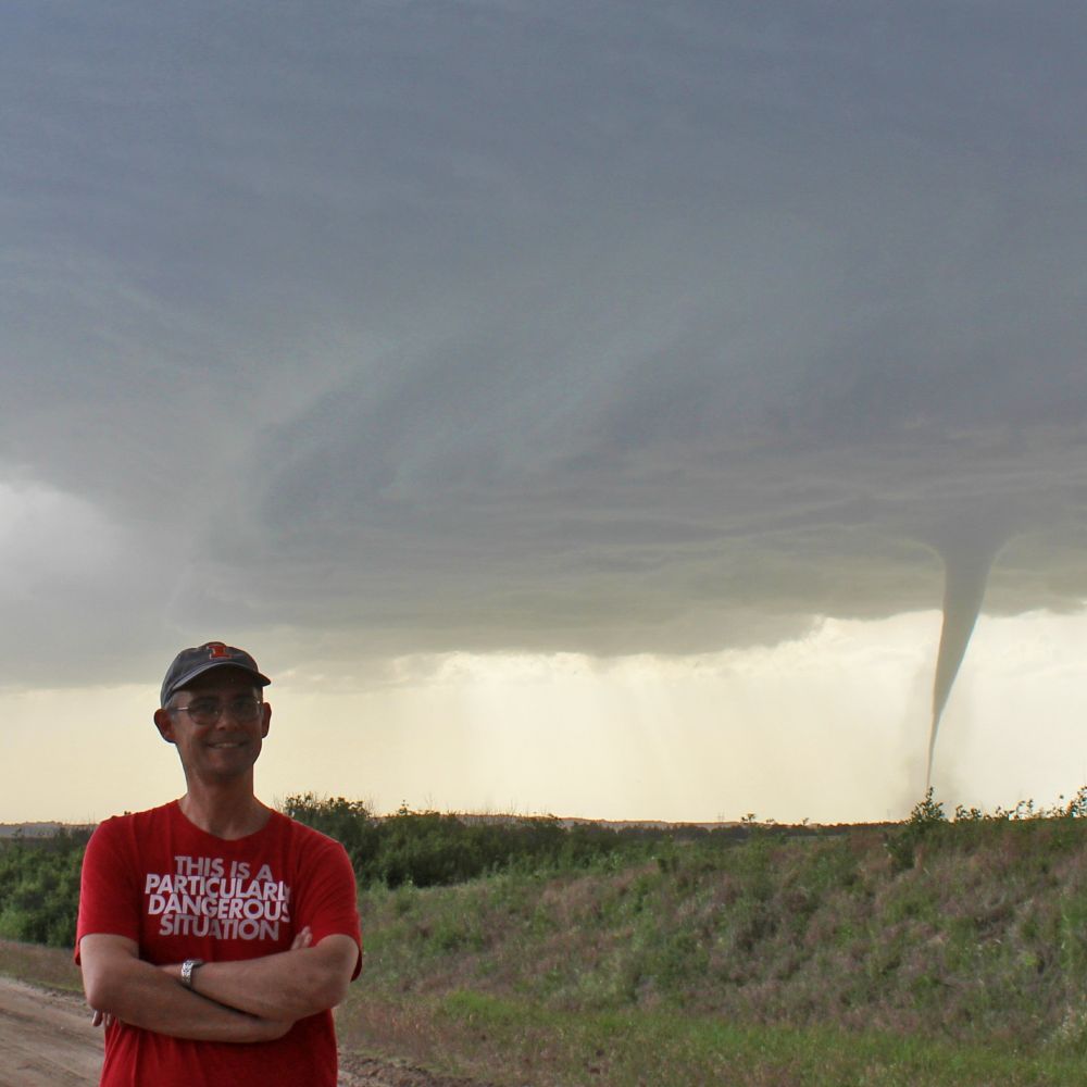
A screen capture of the Fairview ‘, OK tornado from Jeromy Carter.
06.03.2026 03:30
👍 34
🔁 10
💬 0
📌 2


A clear tornado debris signature southwest of Jet, OK. Not too far from the Vance AFB 88D.
06.03.2026 03:33
👍 17
🔁 4
💬 1
📌 0
Thanks!
06.03.2026 03:27
👍 0
🔁 0
💬 0
📌 0

IEMBot Image
At 10:20 AM CST, 2 ENE Urbana [Champaign Co, IL] Mesonet reports Rain of 2.12 Inch. Event total starting March 3. #ilwx Link
06.03.2026 00:26
👍 1
🔁 1
💬 0
📌 0
I'll be a panelist on Fox Weather discussing the severe weather potential tomorrow at 9:15pm CT tonight
06.03.2026 01:25
👍 8
🔁 1
💬 0
📌 0

I’m often asked “did you see the storm over X - what’s going on?” I would then scramble to one of the many wx sites to make a sounding. What if there was a site that specialized in soundings?
Look no further…announcing the beta launch of illiniweather.web.illinois.edu/skewt-intera...
Feedback plz!
05.03.2026 14:28
👍 57
🔁 17
💬 8
📌 2
The environment isn't that impressive
05.03.2026 14:04
👍 0
🔁 0
💬 0
📌 0
Current models are depicting mainly disorganized storms over Illinois late Friday night
05.03.2026 13:59
👍 5
🔁 0
💬 1
📌 0
Some exciting news to share: very soon, NOAA Research will be hiring new federal employees into science positions across the agency! A couple of notes:
1) They will only be open on USAJobs for seven days.
2) Multiple positions at different sites may be in one posting.
(1/2)
04.03.2026 23:55
👍 67
🔁 35
💬 3
📌 1

IEMBot Image
ILX issues Dense Fog Advisory till Mar 5, 6:00 AM CST Link
05.03.2026 01:09
👍 1
🔁 1
💬 0
📌 0

A photo of a slightly-structured supercell thunderstorm with a dark base hovering over a dry, yellow-brown field with a pile of large branches sticking up into the air.
First little supercell chase of the year in my backyard. This was my view of the severe-warned storm east of Atoka, OK at ~5:55 p.m. this evening. #okwx
05.03.2026 01:22
👍 97
🔁 10
💬 1
📌 0
Ope
04.03.2026 15:25
👍 13
🔁 2
💬 2
📌 0

In the modern era of naming Atlantic tropical cyclones (since 1979), 72 names have now been retired. The 2025 season used List V, which was first used in 1983 and every six years hence. With Melissa's retirement, it now leads the pack in terms of the number of retired names from a list at 15.
[1/2]
04.03.2026 17:18
👍 9
🔁 5
💬 2
📌 1
Melissa joined quite a list of retired M storms, all since 1995:
Milton 2024 (tied strongest Gulf)
Michael 2018 (Cat. 5 Fla. Panhandle)
Maria 2017 (PR catastrophe)
Matthew 2016 (Haiti catastrophe)
Michelle 2001 (Cat 4 Cuba)
Mitch 1998 (C. America; 9,000+ killed)
Marilyn 1995 (PR, VI billion $)
04.03.2026 17:31
👍 6
🔁 5
💬 0
📌 2

There is the first ever 5# tornado risk. As a chaser, I’ve been waiting forever for this incredible change. I will be leaving tonight to cover tomorrow and Friday’s severe weather events in Texas & Oklahoma. #txwx #okwx
04.03.2026 18:01
👍 13
🔁 3
💬 0
📌 2

IEMBot Image
ILX issues Summary Local Storm Report Link
04.03.2026 13:33
👍 1
🔁 1
💬 0
📌 0