
For devs & analysts: We’ve exposed API endpoints to wire these reports programmatically into your own dashboards.
Access the reporting tool at reports.climateengine.org
Access the API docs at docs.climateengine.org/docs/build/h...
16.12.2025 23:05
👍 1
🔁 0
💬 0
📌 0

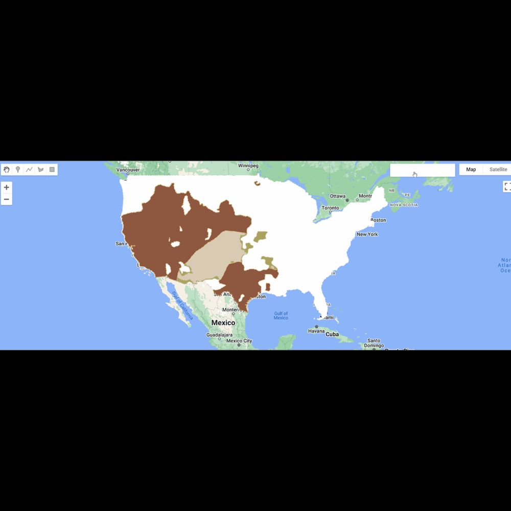
The reports combine near real-time Rangeland Analysis Platform Production with gridMET precipitation data as PDFs/PNGs for use in reporting and decision processes.
Use in: ✅ Grazing planning & evaluation ✅ Drought assessment
Use the custom tool for any CONUS AOI or access pre-computed BLM reports.
16.12.2025 23:05
👍 1
🔁 0
💬 1
📌 0

📈 New from ClimateEngine.org: Vegetation Production Reports!
Developed with partners at the BLM and USDA-ARS, these reports bring satellite-based rangeland data directly into grazing and resource management workflows. Bridging the gap between data and decision-making. 🛰️🌾
#RemoteSensing #Geospatial
16.12.2025 23:05
👍 3
🔁 1
💬 1
📌 0
NOAA's National Integrated Drought Information System has supported and leveraged @climateengine.org from the very beginning — thank you NOAA!
We'll be posting many more updates on the ClimateEngine.org bsky account, so be sure and follow ➕
12.12.2025 18:39
👍 1
🔁 1
💬 0
📌 0

Data at Your Fingertips: Everything You Need to Know To Get Started With Climate Engine
On-Demand Insights from Climate and Earth Observations Data
Testing, testing, is this thing on 🎤
@climateengine.org is live on Substack! ✍️
Read our first article, which surveys the free and public tools that Climate Engine provides, supporting access to 90+ #EarthObservations time-series datasets for analysis.
substack.com/home/post/p-...
#EarthEngine
08.12.2025 18:09
👍 4
🔁 1
💬 0
📌 0

5.9" in west Fort Collins (Taft Hill and Mulberry). First overperformer up here in a LONG time.
03.12.2025 12:44
👍 2
🔁 0
💬 0
📌 0
New masking options:
💧 Map Landsat NDVI trends only in riparian areas.
🌲 Track USFS Tree Canopy Cover over NLCD forest classes.
➕ Apply up to 2 masks (union or intersection).
Docs: support.climateengine.org/article/198-...
What will you try?
#RemoteSensing #EarthEngine #ClimateEngine
20.11.2025 23:22
👍 2
🔁 1
💬 0
📌 0
🎯 Focus your maps with categorical data! 🎯
New in Climate Engine: categorical masks to focus maps by land ownership, landcover, valley bottoms, and more.
In the demo video, see Landsat NDVI trends (1985–2025) across riparian areas at Maggie Creek, Nevada.
🌎 Try it at app.climateengine.org
20.11.2025 23:22
👍 6
🔁 2
💬 1
📌 0
🗺️ New raster overlays in Climate Engine! 🗺️
You can now add contextual overlays to your CE maps:
🌍 Landcover (NLCD, ESA WorldCover),
🏛️ Land ownership (Surface Management Agency)
💧 Wetlands (NWI, VBET)
What layers do you want to see added to Climate Engine?
#EarthObservations #Climate #Geospatial
10.11.2025 14:22
👍 3
🔁 2
💬 1
📌 0
🗺️ Climate Engine is looking sharper than ever with new basemaps!
You can now add high-res aerial imagery and topographic layers beneath your computed maps to explore fine-scale landscape detail.
Check out the demo and try it at app.climateengine.org
🌎
#EarthEngine #RemoteSensing #Geospatial
07.11.2025 17:39
👍 23
🔁 5
💬 1
📌 0

New basemap options include:
🛩️ NAIP imagery (true color, color infrared, NDVI),
🗺️ Historical imagery from the USGS archive
🌐 1-m topography layers from USGS 3DEP.
These layers bring landscapes into focus and make it easier to interpret satellite data
#EarthEngine #NAIP #3DEP #EarthObservation
07.11.2025 17:39
👍 4
🔁 0
💬 0
📌 0
🗺️ Climate Engine is looking sharper than ever with new basemaps!
You can now add high-res aerial imagery and topographic layers beneath your computed maps to explore fine-scale landscape detail.
Check out the demo and try it at app.climateengine.org
🌎
#EarthEngine #RemoteSensing #Geospatial
07.11.2025 17:39
👍 23
🔁 5
💬 1
📌 0


🚨 New Climate Engine data tools! 🚨
This week we're excited to introduce @climateengineorg.bsky.social reports for anywhere in CONUS. Created for resource managers, policymakers, and others, the reports aid in reporting, monitoring, and adaptive management.
🛠️ Use the tools reports.climateengine.org
31.01.2025 15:39
👍 8
🔁 3
💬 1
📌 0
Generating Climate Engine Reports for Custom Areas of Interest
YouTube video by Climate Engine Org
To help to support users, we've published a tutorial video that demonstrates using a 'Priority Region', 'Shapefile Upload', or 'Drawn Polygon' for your AOI for lands administered by BLM, NPS, USFS, USFWS, BIA, DOD, or all lands.
📺 See the video www.youtube.com/watch?v=b4yj...
31.01.2025 15:39
👍 3
🔁 1
💬 1
📌 0
🚨 New Climate Engine data tools! 🚨
This week we're excited to introduce @climateengineorg.bsky.social reports for anywhere in CONUS. Created for resource managers, policymakers, and others, the reports aid in reporting, monitoring, and adaptive management.
🛠️ Use the tools reports.climateengine.org
31.01.2025 15:39
👍 8
🔁 3
💬 1
📌 0
Today's fun task was to figure out how to dynamically visualize a DEM in the #EarthEngine Code Editor. 🌐
This script pulls the minimum and maximum values at the extent of the viewport to ensure the color ramp never saturates. 🌈
Check it out for yourself: code.earthengine.google.com/9eadd135b3b5...
11.12.2024 23:35
👍 8
🔁 1
💬 0
📌 0

Announcing Geo for Good Impact Awards: Recognizing our community
By Devaja Shah, Program Manager, Google Earth Outreach
Our team at @DRIScience is honored to be recognized as one of the inaugural recipients of the #GeoForGood23 Impact Awards! 🛰️
Thank you to Google Earth Outreach for highlighting the work of the exemplary partners selected 🙏
medium.com/google-earth...
13.10.2023 19:46
👍 5
🔁 4
💬 0
📌 0


DRI's own Dr. Tim Brown recently had the opportunity to present at #IndyFest2023 on the panel for #Wildfires Sciences and Management. We would like to thank @thenvindy.bsky.social for the opportunity to discuss ways to create more resilient communities. #DiscoverDRI dri.edu/cefa
11.10.2023 15:35
👍 2
🔁 1
💬 0
📌 0

#GeoForGood23 begins 👨🏼💻
10.10.2023 16:07
👍 4
🔁 0
💬 0
📌 0
How ClimateEngine.org and Awesome GEE Community Catalog are Expanding Open Geospatial Commons
In conversation with Justin Huntington and Eric Jensen
Thrilled that our ClimateEngine.org team is able to share 29 of our previously-internal datasets — sourced from NOAA, Copernicus, NASA, and others — with the #EarthEngine community, as part of the Awesome EE Community Catalog!
See the Medium post for all the details: shorturl.at/dzCE7
05.10.2023 20:31
👍 5
🔁 6
💬 0
📌 0


🌐 #Geospatial Job: Outreach Scientist @umontana 🌐
The lab that built the Rangeland Analysis Platform & Landscape Explorer is seeking a technically proficient person with a passion for translating science for conservation action.
shorturl.at/bU123
#EarthEngine #EOChat #GISChat
03.10.2023 13:56
👍 4
🔁 2
💬 0
📌 0

Fantastic to see the USGS Historical Imagery mosaic produced by USDA-NRCS Working Lands for Wildlife in the #EarthEngine Community Catalog!
gee-community-catalog.org/projects/his...
I had the privilege of working on the project in 2020-2021 — tremendous opportunities in conservation and beyond.
27.09.2023 15:42
👍 6
🔁 3
💬 1
📌 0

We're excited to share that we're adding dozens of our #EarthEngine assets to the EE Community Catalog!
The first batch includes USGS VIIRS and MODIS Evapotranspiration, CEMS Fire Danger Indices, the North American Drought Monitor, and more 🛰️
Catalog changelog: gee-community-catalog.org/changelog/
27.09.2023 15:25
👍 3
🔁 2
💬 0
📌 0

Postdoctoral Scholar: Spatial Ecology - Fort Collins, Colorado
The postdoc will lead research projects assessing drought exposure and risk under climate change for sensitive wildlife species in California and across the US. They will be responsible for spatial an...
2nd research opportunity now available! We seek a spatial ecologist to lead projects on drought impacts on wildlife. Based in Fort Collins, CO; with @johnmola.bsky.social, Jen Costanza (US Forest Service), Ryan Peek (CA Fish & Wildlife) & myself. Postdoc (link below) or "post-masters" (next post)
🧪🌍
22.08.2023 03:24
👍 24
🔁 18
💬 1
📌 1

Adapting Western US Forests to Climate Change & Wildfires:
Ten Common Questions
Check out this awesome StoryMap about adapting western US forests to climate change and wildfires.
It provides a nice overview of this 🧪 paper: https://doi.org/10.1002/eap.2433
16.08.2023 23:05
👍 13
🔁 7
💬 2
📌 0

*** #Geospatial Job Opening ***
Spatial Analyst and Decision Support Specialist position for the Colorado Forest Restoration Institute (CFRI) at Colorado State University in Fort Collins. $65-75k.
More information here: https://lnkd.in/gav54sgz
#GISchat #GISjobs
03.08.2023 16:18
👍 5
🔁 2
💬 0
📌 0


Sea Surface Temperatures are 2-6 degrees C above average for this date across large swaths of the Atlantic and Mediterranean.
The high ocean temperatures are the warmest of the past four decades for this date in many locations.
Source: NOAA OISST using ClimateEngine.org
#Climate #Geospatial
26.07.2023 15:13
👍 1
🔁 0
💬 0
📌 0

Three women standing for a photo. From left to right, Morgan Crowley, Africa Flores-Anderson and Barb Ryan.

Two rows of people smiling, four in back, two in front. One man in front looking at other man in front. Set in front of satellite image.

Three women standing in a row, from left to right, Sabrina Szeto, Morgan Crowley, and Nikki Rae Tulley. All smiling.

Morgan Crowley presenting from podium, the slide says “A multi-disciplinary approach to making EO accessible and inclusive.” Another woman takes notes in the background.
Hey folks! I am new here 👋. I am a Forest Fire Research Scientist with the Canadian Forest Service (NRCan). I use satellite data to monitor wildfires and support Canadian fire agencies. I am an advocate of open access data and DEIJ in remote sensing & Earth Observations!
GISChat EOChat 🔥🌲🛰️📡🚀👩💻💻🧪🔬
04.07.2023 00:29
👍 26
🔁 8
💬 1
📌 1


