How large is Greenland, really? Your map may be deceiving you
Talk of annexation has Greenland in the news again. But due to quirks of cartography, some common maps show the territory much larger than it is.
If this Greenland nonsense makes people appreciate map projections maybe there's some benefit, though I'm sure if a certain someone found out it's real size he'd be less keen. Maybe Denmark price it based on Mercator 🤣 www.npr.org/2026/01/07/n...
08.01.2026 02:55
👍 8
🔁 2
💬 1
📌 0
ArcGIS Enterprise 11.5: Key considerations for your upgrade
YouTube video by Esri Australia
What's new in #ArcGIS Enterprise 11.5 and migrating content from the tilecache to the object store
youtu.be/2TJNpyxlnyA
27.06.2025 06:47
👍 1
🔁 0
💬 0
📌 0

1st March saw some relaxing of the rules for Google Street View. This means we can now access it apps like ArcGIS Experience Builder. www.bgtdevhub.com/widget-colle...
25.03.2025 07:56
👍 1
🔁 0
💬 0
📌 0


The BOM GIS2Web is a great service that can be used for ingesting in your GIS for any workflows around #cyclone #Alfred
04.03.2025 02:56
👍 0
🔁 0
💬 0
📌 0

Simple Automate flow to purge out old records from an #Arcgis Online feature service. Another process is archiving this data, but this could also be achieved in this flow.
02.03.2025 01:21
👍 0
🔁 0
💬 0
📌 0
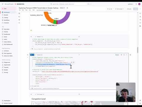
Ingesting and crunching GTFS-Realtime data in New South Wales to try and work out congestion and 'standing room only' hotspots.
youtu.be/K9FZu5K-wQ0
21.01.2025 01:10
👍 0
🔁 0
💬 0
📌 0
Using #Azure weather services & basemaps in #ArcGIS. Great post from Esri Canada - resources.esri.ca/getting-tech...
10.01.2025 07:00
👍 1
🔁 1
💬 0
📌 0
Databricks and ArcGIS: Breaking down big data - Danny Wong
YouTube video by Esri Australia
Glad to hear this as planning on blogging it and sharing notebook in January. There is a recording here with Databricks youtu.be/XOt5CnYmM4U?...
30.12.2024 22:02
👍 1
🔁 0
💬 0
📌 0

Grampians bushfire spreads to over 74,000 hectares. National bushfire extents synced to state feeds digital.atlas.gov.au/pages/8b1247...
26.12.2024 22:18
👍 0
🔁 0
💬 1
📌 0
Thanks for this. For now, im pushing main devices to homekit via homekit bridge and Siri is doing an ok job in our house. Looking forward to going entirely local one day.
24.12.2024 07:51
👍 0
🔁 0
💬 0
📌 0
Keep us posted, very interested to add this to my setup.
24.12.2024 05:03
👍 0
🔁 0
💬 1
📌 0

Grampians bushfire - Sentinel imagery from 20th December
21.12.2024 02:01
👍 2
🔁 0
💬 0
📌 0

This is for future me. The land borders of Australia. Lines, not polygon states. Very handy. digital.atlas.gov.au/datasets/0ab...
03.12.2024 01:08
👍 0
🔁 0
💬 0
📌 0
Australian Bureau of Statistics (abs) providing this to “Australian Climate Service (ACS). This data will support better response, relief and recovery to disasters”
www.arcgis.com/home/item.ht...
20.11.2024 20:08
👍 2
🔁 0
💬 0
📌 0
Testing Esri AI Assistants with ABS content.
20.11.2024 09:16
👍 4
🔁 1
💬 1
📌 0


Using #Databricks and #ArcGIS Geoanalytics Engine to calculate walk/drive times for 1M Overture buildings in Sydney, for a series of facilities. Will post workings and layer in a blog before the end of the year.
20.11.2024 06:44
👍 0
🔁 0
💬 1
📌 0