Spiritual shopping, Anthony Bourdain and the fragility of 'home'
Where are we?
My daughter's first Substack post - In our modern world of "spiritual shopping," many of us are engaged in a restless search for belonging—a symptom of cultural homelessness in a society that commodifies meaning but offers no real home.
open.substack.com/pub/amitydel...
05.09.2025 11:56
👍 1
🔁 0
💬 0
📌 0

The #EUGW team had a blast at @esa.int's #LPS25 this week❗
We are grateful for the insightful discussions, new connections, and shared passion for #EO and land monitoring 🌱
A big thank you to everyone who attended our presentation, we appreciate your interest and enthusiasm 🌾
27.06.2025 15:04
👍 5
🔁 2
💬 1
📌 0
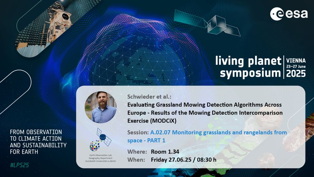
Announcement for upcoming Earth Observation Lab contribution at living planet symposium 2025:
Schwieder et al.:Evaluating Grassland Mowing Detection Algorithms Across Europe - Results of the Mowing Detection Intercomparison
Exercise (MODCiX)
Session: A.02.07 Monitoring grasslands and rangelands from space - PART 1
Where: Room 1.34
When: Friday 27.06.25 / 08:30 h
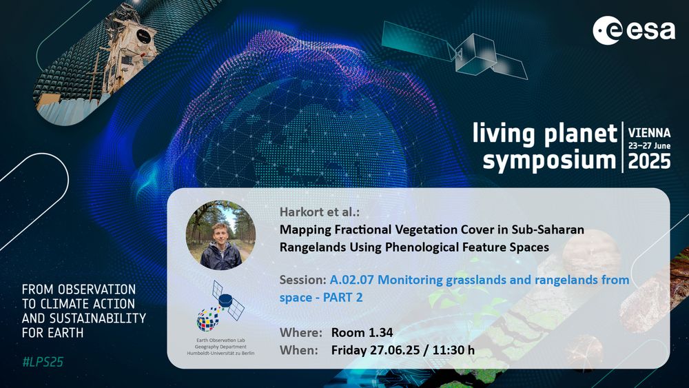
Announcement for upcoming Earth Observation Lab contribution at living planet symposium 2025:
Harkort et al.: Mapping Fractional Vegetation Cover in Sub-Saharan
Rangelands Using Phenological Feature Spaces
Session: A.02.07 Monitoring grasslands and rangelands from space - PART 2
Where: Room 1.34
When: Friday 27.06.25 / 11:30 h
Don’t miss EOLab’s contributions to #LPS25 Session A.02.07 - Monitoring Grasslands and Rangelands from Space
Part 1 with Dr. Marcel Schwieder at 8:30
Part 2 with @lasseharkort.bsky.social at 11:30
See you at Room 1.34!
27.06.2025 05:12
👍 9
🔁 2
💬 1
📌 0
For those who don't know it yet. There is a feed for Living Planet. You can pin it to your start page. This makes it easy to follow activities around ESA Living Planet.
buff.ly/hBXTBPx
#LPS25 | #EsaLivingPlanet | #LivingPlanetSymposium
#EarthObservation #RemoteSensing
23.06.2025 05:35
👍 1
🔁 1
💬 0
📌 0

Some #ESA #sentinel2 data showing the floodwaters in the outback - this extract covers Noccundra and Thargominda in the north to the Queensland NSW border in the south.
10.04.2025 05:29
👍 2
🔁 0
💬 0
📌 0

MODIS water index showing the extent of the following in Western Queensland
The scale of the flooding in Western Queensland is phenomenal.
Here's a mosaic of MODIS TERRA imagery for 2025-04-04 with water extent in blue and a 600km scale bar for comparison.
06.04.2025 02:34
👍 7
🔁 2
💬 0
📌 1
No it's a 500 X 500km area about 1000km West of Brisbane. The western side of it is currently covered in flood waters so it was a bit hard to get out there for field work.
05.04.2025 21:03
👍 1
🔁 0
💬 0
📌 0

Satellite Time Series mapping of land condition indicators across southwest Queensland, Australia
I've been road-testing some #RemoteSensing #LandCondition indicators in #QLD:
🔴 RESTREND (decreasing groundcover relative to rainfall)
🟢 Annual vs Perennial grass (dominance of annuals)
🔵 Landscape Function Index (cover resilience)
Brighter colour combinations = reduced #LandscapeFunction
04.04.2025 23:49
👍 3
🔁 0
💬 1
📌 0
Knowledge is never knowing the answer. It’s knowing the territory.
18.02.2025 01:50
👍 2340
🔁 396
💬 38
📌 46
Foliage Cover over Australia Ozius Biome - Biome 3D Vegetation Structure 2020
21.11.2024 09:23
👍 16
🔁 2
💬 1
📌 0

Starting my posts here with a pretty (to me :) map of the first three PLS components of fractional cover time series against soil carbon plots, capturing the contrast between Mitchell Grass, Spinifex, and the Mount Isa Inlier. Next step: pump this through the brilliant www.pyshepseg.org library
19.11.2024 06:47
👍 9
🔁 1
💬 1
📌 0