This delivery driver throws treats to all the dogs on his route to see if they can catch. Spoiler alert: some of them definitely cannot. Still 13/10 for all (TT: jezzyvi)
05.03.2026 20:20
👍 6513
🔁 904
💬 112
📌 69
Ouch.
04.03.2026 21:03
👍 1
🔁 0
💬 0
📌 0

Glacier Loss in Alaska
Alaskan glaciers are retreating faster than ever, threatening ecosystems, communities, and ways of life. ❄️
Join me and others for a webinar on glacier loss, tipping points, and cultural consequences in Alaska.
🗓 Monday, March 23
⏰ 18:00–19:30 CET
🔗 futureearth.confetti.events/glacier-loss...
03.03.2026 17:24
👍 9
🔁 6
💬 0
📌 0
Happy International Polar Bear Day!
28.02.2026 00:07
👍 4
🔁 0
💬 0
📌 0

View from a small fixed-wing plane. A gray-blue strip of the North Pacific ocean fills the bottom edge of the scene. A narrow strip of beach is cut in half by a river emptying into the ocean. Tree-covered moraine rises behind the beach. A lake sits behind the moraine on the left of the image with the edge of the Malaspina Glacier (with alternating bands of dark moraine and white ice) is visible just behind the lake. The front of the St. Elias Mountains sits in the distance. Most of the scene is cloudy, but sun is shining down on the snow and ice of the mountains.

A beach, with grass and trees on the left and mist-covered surf on the right, fills the lower half of the image. The beach is a mix of rocks and sand with some driftwood. A line of tracks stretches long the beach. In the background, the snow and ice covered St. Elias Mountains rise.

A beach with gray sand and rocks. Very fresh bear tracks, with foot pads and claws quite visible, runs down the middle of the dry sand. To the right of the fresh tracks there are additional tracks that are partially worn away. This appears to be a popular bear route.

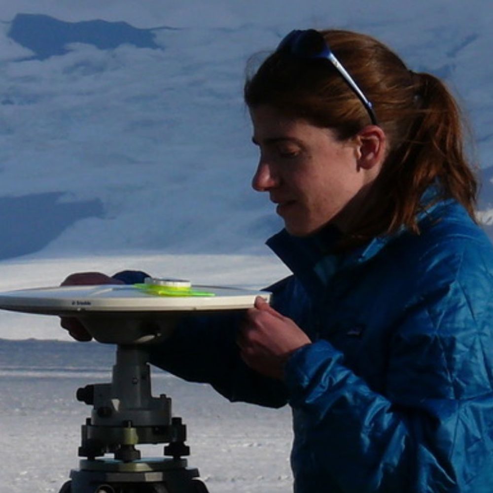
A yellow survey tripod holds a white GNSS antenna. A large yellow Pelican case at the bottom holds a GNSS receiver. A white garbage bag next to the Pelican case holds a battery to power the station. Vegetation, some of which was prickly, surrounds the tripod. Trees fill the background behind the site.
Going through old field photos and found these from a trip to survey a benchmark near the Malaspina Glacier. When we landed on the beach, we discovered that an unwelcome field assistant had recently come through. The pilot kept watch while I set up the site. #FieldworkFriday #FieldPhotoFriday ⚒️🧪
27.02.2026 16:01
👍 6
🔁 1
💬 0
📌 0
"I destroyed this thing last year and that lady put it back up. Humans sure are slow learners."
26.02.2026 19:08
👍 2
🔁 0
💬 0
📌 0
If you fly into FBX and drive down the Richardson, you can see the Denali fault pipeline crossing, Alaska Range, Wrangells, Glacial Lake Atna deposits, Chugach Mtns, glaciers, and old town Valdez (damaged in and abandoned after 1964 eq). And maybe some caribou. Pretty decent bang for the buck.
26.02.2026 00:23
👍 0
🔁 0
💬 0
📌 0
That was fun! Thanks for having me. You have a great group of students who asked excellent questions.
25.02.2026 19:47
👍 1
🔁 0
💬 1
📌 0

Landslide and Avalanche Debris Litter Hubbard Glacier - NASA Science
Satellite-based radar images show where a powerful earthquake in the Yukon, Canada, sent rock, snow, and ice spilling across the frozen landscapes of the St. Elias Mountains.
NASA Earth Observatory Image of the Day today is NISAR images acquired before and after the magnitude 7 Hubbard Glacier Earthquake in Yukon near the border with Alaska. It shows the huge number of landslides and avalanches in the mountains triggered by the earhtquake science.nasa.gov/earth/earth-...
25.02.2026 16:34
👍 5
🔁 3
💬 1
📌 0

Text head says Geology vs. Geodesy. Below there are two pictures. One is a GNSS site with eyeballs and angry looking eyebrows pointing towards each other. The other is a hillside showing geologic strata, a fault, and some folds. Eyeballs are placed at the ends of the folds with angry eyebrows. A frown mirrors the geologic strata. The ultimate showdown is on.
Just made this graphic for a talk. Why, yes, I am tired. Why do you ask? ⚒️
25.02.2026 16:27
👍 7
🔁 1
💬 2
📌 0
This was likely the view from several of my GNSS stations right before they were wrecked (and/or shoved off a cliff).
24.02.2026 22:27
👍 4
🔁 1
💬 1
📌 0
I remember getting my box!
24.02.2026 00:47
👍 2
🔁 0
💬 0
📌 0

I'm very pleased to have publically archived what I think is an exceptional seismic data set. 5 months from 8 stations on the ablation area of the West Greenland ice sheet, NE of Ilulissat. Very good data quality and uptime spanning the entirety of the ablation season.
ds.iris.edu/gmap/#networ...
19.02.2026 19:31
👍 10
🔁 2
💬 1
📌 0
⚒️🧪🌋
19.02.2026 17:41
👍 5
🔁 2
💬 0
📌 0

A zoomed in look at 4 scientists working with the a lava fountain covering the entire background.

A very tall lava fountain with tiny dots (people) near the base. The image is a bit forced perspective and we are not as close as it looks
Someone captured my colleagues an I servicing the cameras during Kīlauea’s episode 42. We stopped to discuss what we were seeing, but because I talk with my hands it looks like I’m fixing to push someone in…
Credit: Volcano Hideaways
16.02.2026 22:49
👍 2290
🔁 337
💬 98
📌 23

Comic. Bad Map Projection #216: Zero Declination. A cylindrical projection distorted so that up is *magnetic* north. Distorted map with red arrows around the edges pointing different directions.
Bad Map Projection: Zero Declination
xkcd.com/3207/
16.02.2026 20:16
👍 1571
🔁 143
💬 20
📌 9
Deadline extended to March 1! No geodesy experience required. Just interest in learning more and some prior experience in programming and/or math (calculus level or beyond). ⚒️🧪
16.02.2026 16:21
👍 3
🔁 2
💬 0
📌 0
I was going on the 10 days and figured the March was a typo. Feb. 25 is fine with me.
16.02.2026 13:56
👍 1
🔁 0
💬 1
📌 0
Timing works just fine. I have projects in the Wrangells and Edgecumbe areas, both weirdo volcanic fields (and thus fun). I can do some show and tell with some metamorphic rocks I picked up in the St. Elias and tie them into past/current tectonics there.
16.02.2026 01:33
👍 3
🔁 0
💬 1
📌 0
If you'd be interested in subduction zones, Alaska tectonics, and/or geodesy I could give a talk.
16.02.2026 01:13
👍 3
🔁 0
💬 1
📌 0

Gladys Mae West obituary: mathematician who pioneered GPS technology
She made key contributions to US cold-war science despite facing huge barriers as a Black woman.
Mathematician Gladys West helped develop satellite geodesy models that went on to become the foundations for GPS and used to optimize the orbit of GPS satellites. She passed away last month at age 95.
#BlackHistoryMonth
12.02.2026 15:37
👍 23
🔁 7
💬 0
📌 0
There are, but many of them aren't indexed by Scopus. If you're at an institution that judges you on metrics related to that, it becomes a problem (sadly).
11.02.2026 21:20
👍 0
🔁 0
💬 0
📌 0
Unfortunately, open access can be quite costly.
11.02.2026 19:48
👍 0
🔁 0
💬 1
📌 0
Wow. Is there a volcano tissue box cover anonymous group? :)
11.02.2026 18:43
👍 2
🔁 0
💬 1
📌 0
There's still time to apply to mentor a student intern this summer!
Interns are fully funded for 11 weeks, so mentors can focus on research guidance and professional growth, rather than logistics. Mentor training and support are also provided.
Apply by February 15
⬇️
loom.ly/lQblWA4
10.02.2026 19:58
👍 4
🔁 4
💬 0
📌 0

App State students surveying a wetland in Environmental Science Field Methods
We’re hiring a NTT lecturer in the Department of Geological and Environmental Sciences at Appalachian State University! We are a big (>300 majors) collegial undergraduate-only department in the Blue Ridge Mountains (southeastern US). See the full job post:
appstate.peopleadmin.com/postings/53077
10.02.2026 13:54
👍 2
🔁 1
💬 0
📌 1
I didn't notice. I think my brain just filled in the "Survey" part.
10.02.2026 04:01
👍 2
🔁 0
💬 1
📌 0