I've since learned from a Cleveland resident that, when wealthy Cleveland-adjacent suburbs were drawing their boundaries, they thought that somehow these jagged boundaries would create a buffer between their cities and Cleveland. This was during the early 1900s.
23.02.2026 22:05
👍 5
🔁 0
💬 1
📌 0

zoomed in weird jagged city boundaries following land parcels, but sometimes cutting through parcels.
In most cases, it is following parcels, but not always.
13.02.2026 22:41
👍 2
🔁 0
💬 1
📌 0

screen shot of google earth image showing jagged city boundary at a very large zoomed in scale.
even little right angles smaller than the blocks
13.02.2026 20:24
👍 6
🔁 1
💬 3
📌 0
jagged city boundary on a map
I don't know. Look at this jaggedness. Fascinating.
13.02.2026 20:21
👍 2
🔁 0
💬 3
📌 0

screen shot of google earth image showing a small part of Cleveland's very jagged city boundary.
I'm making a map of Cleveland, Ohio, and I thought I had bad data because of a long wobbly border between Cleveland and Shaker Heights. Turns out, Cleveland just has a very jagged boundary.
13.02.2026 20:03
👍 11
🔁 2
💬 7
📌 0
Good morning from Seattle, where the vibe has a dose of joy today 💙💚
09.02.2026 15:14
👍 14
🔁 0
💬 0
📌 0
Well, I may not be getting much sleep tonight. People are celebrating loud! Fireworks 🎆
Way to go HAWKS!
09.02.2026 03:33
👍 3
🔁 0
💬 0
📌 0

Photo of television showing Superbowl
I have a serious shoulder injury & see a renowned specialist tomorrow at 7:30am. Rather than brave Seattle morning rush hour, I drove down tonight and am watching the Super Bowl alone in a hotel.
💙💚 Go HAWKS 💚💙
(And good vibes to the shoulder so I can climb again!)
08.02.2026 23:53
👍 15
🔁 1
💬 1
📌 0
I wish that others didn’t remain silent.
24.01.2026 21:04
👍 1
🔁 0
💬 1
📌 0
I cannot “heart” this post because it is a tragedy. But I want you to know I see you and your rage, and applaud you for not remaining silent.
24.01.2026 19:05
👍 0
🔁 0
💬 1
📌 0
It’s kidnapping.
22.01.2026 06:17
👍 4
🔁 0
💬 0
📌 0
Good read. I do feel like rabid raccoons may have more self control.
19.01.2026 21:37
👍 1
🔁 0
💬 1
📌 0
Hugs. Wisely was a good boy. 🐾
16.01.2026 16:07
👍 1
🔁 0
💬 0
📌 0
No. The court ruled on Presidential immunity and it still only applies to specific official acts. Federal agents do not have absolute immunity.
09.01.2026 00:09
👍 0
🔁 0
💬 1
📌 0
Yesss! I changed symbolization from opacity to hue & built a palette that leans into moody sunset tones. Opacity wasn't delivering the drama of solstice extremes. Hue gives the emotional weight it deserves. I’m enjoying how this prototype is coming together. Daylight Hours over span of 1 year.
02.01.2026 21:47
👍 12
🔁 0
💬 1
📌 0
This is a good part of the process, imho! Get it all out there for editing and updating. Every map is "unfinished."
30.12.2025 21:28
👍 2
🔁 0
💬 0
📌 0
Totally. It can be applied for several situations. In this particular one, I tend to share work-in-progress maps long before they're ready for prime time. I get excited.
30.12.2025 21:25
👍 2
🔁 0
💬 1
📌 0
Animating opacity doesn't provide the visual drama to match the reality of daylight hour differences. I'm going to experiment with hue, but want the operational data (upcoming) to pop, thus hue may steal this. These are the types of challenges I love as a geovisualization designer!
30.12.2025 21:21
👍 4
🔁 0
💬 0
📌 0
My eagerness for mapmaking surpasses my patience. Here's an early look at my proof-of-concept animation showing daylight hours per each 5-deg latitude band over the span of one year. Built with ArcGIS Pro, python, Maps for Adobe, Illustrator, After Effects, JavaScript/TS. 1/
30.12.2025 21:18
👍 19
🔁 3
💬 3
📌 1

Liberty Bell Mountain, North Cascades.
Happy Winter Solstice Eve!
Cheers to brighter days ahead ❄️
Photo: Liberty Bell Mountain group, North Cascades.
21.12.2025 05:50
👍 22
🔁 0
💬 0
📌 1
Even when the reader knows the anatomy well, the labeling and ID graphics are typically in black or white. Bad choice for these images. Sometimes they use red or green, which is worse. These are my Friday night musings yall. I should go distract myself and watch the latest Pluribus.
06.12.2025 02:05
👍 3
🔁 0
💬 1
📌 0
😮
29.11.2025 02:08
👍 0
🔁 0
💬 0
📌 0

Fifteen Years
i’m not crying you’re crying
xkcd: Fifteen Years
25.11.2025 01:58
👍 5038
🔁 1347
💬 77
📌 142

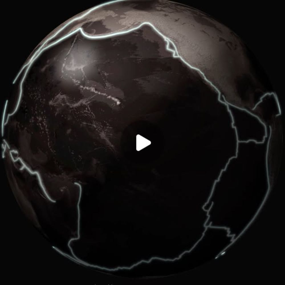
Globe centered on Pacific Ocean. Rendered to appear as though it is sitting atop a flat surface.
#30DayMapChallenge Day 22: Natural Earth data.
Made in Pro & Illustrator. Lighting drawn in vector artwork in Illustrator.
22.11.2025 16:42
👍 11
🔁 0
💬 0
📌 0
😊 thanks!
20.11.2025 03:08
👍 1
🔁 0
💬 0
📌 0
Thanks!
20.11.2025 02:36
👍 1
🔁 0
💬 0
📌 0
Thanks! It’s the quick version, but I’d enjoy spending more time with it to give it more of a magnifying dome effect.
19.11.2025 18:25
👍 2
🔁 0
💬 0
📌 0

Two global maps superimposed with different projections
#30DayMapChallenge Day 19: Projections
Equal Earth and web Mercator, both aligned at 0, 0.
19.11.2025 17:56
👍 40
🔁 6
💬 3
📌 0
Thanks!
18.11.2025 02:50
👍 0
🔁 0
💬 0
📌 0