The front page of our article in Big Earth Data journal titled "Evaluation of ten satellite-based and reanalysis precipitationdatasets on a daily basis for Czechia (2001–2021)" by Daniel Paluba, Vojtěch Bližňák, Miloslav Müller and Přemysl Štych. Access the study using the DOI link: https://doi.org/10.1080/20964471.2025.2592444
Our new #OpenAccess paper in @bigearthdata1.bsky.social @tandfresearch.bsky.social on evaluation of 10 satellite-based and reanalysis #precipitation datasets on a daily basis for #Czechia
doi.org/10.1080/20964471.2025.2592444
Most accurate: GSMaP & ERA5-Land
Worst results: CHIRPS, GLDAS & PERSIANN
06.12.2025 19:28
👍 1
🔁 1
💬 0
📌 1
Can we estimate optical vegetation indices and biophysical parameters usingSentinel-1 SAR data?
YouTube video by PANGEOS_COST
Now you can watch the recording of my presentation on estimating #NDVI, EVI, LAI and FAPAR using #SAR and ancillary data through #machinelearning approaches during the @pangeos-ca22136.bsky.social webinar, summarizing two studies: doi.org/10.14712/233... & doi.org/10.1080/2096...
#geosky #GEE #EO
28.11.2025 18:24
👍 5
🔁 1
💬 0
📌 0

‼️ Fully-funded #PhD #position on “Integration of Advanced Spectral and Thermal #RemoteSensing Methods and #ArtificialIntelligence for Assessing the State and Functioning of Ecosystems across Scales” at @sciencecharles.bsky.social 🇨🇿
🔗 Detailed info: shorturl.at/GKICI
🗓️ Deadline: December 15, 2025
24.11.2025 14:34
👍 7
🔁 2
💬 0
📌 0

Last Monday, during the @copernicusecmwf.bsky.social C3S User engagement workshop within the #CzechSpaceWeek, I got a chance to present our work on the evaluation of precipitation datasets in Czechia.
The paper is currently under review, but the preprint is available here:
doi.org/10.13140/RG....
28.10.2025 12:16
👍 1
🔁 0
💬 0
📌 0
The event was a joint effort of four #COSTActions: #3DForEcoTech (groud-based LiDAR), #PANGEOS (remote sensing), #CLEANFOREST (tree ecophysiology and ecology) and #ARiF - Augmented Reality In Forestry.
Huge thanks to #PANGEOS for supporting my participation!
#ConnectedByTrees
17.08.2025 17:27
👍 0
🔁 0
💬 0
📌 0
💡@markuseichhorn.bsky.social's keynote on interdisciplinarity reinforced my postdoc goal to step beyond Earth Observation and collaborate across disciplines: to learn more by knowing less.
I also briefly showed my peers how SAR time series can support forest monitoring during the PANGEOS section.
17.08.2025 17:27
👍 0
🔁 0
💬 1
📌 0
In my poster, I also shared new improvements where I incorporated temporal features, applied snow masking and extended the training dataset timeline to five years, which significantly boosted the accuracy of our #MachineLearning models!
👉 My poster is available here: github.com/palubad/SAR-...
01.07.2025 10:16
👍 1
🔁 0
💬 0
📌 0


During the ESA #LPS2025 in Vienna last week, I had the chance to present our work on estimating time series of vegetation indices for Central European #forests using Sentinel-1 #SAR, ancillary data and #ML approaches.
🔗 More details in our paper published earlier this year: doi.org/10.1080/2096...
01.07.2025 10:16
👍 1
🔁 1
💬 1
📌 0
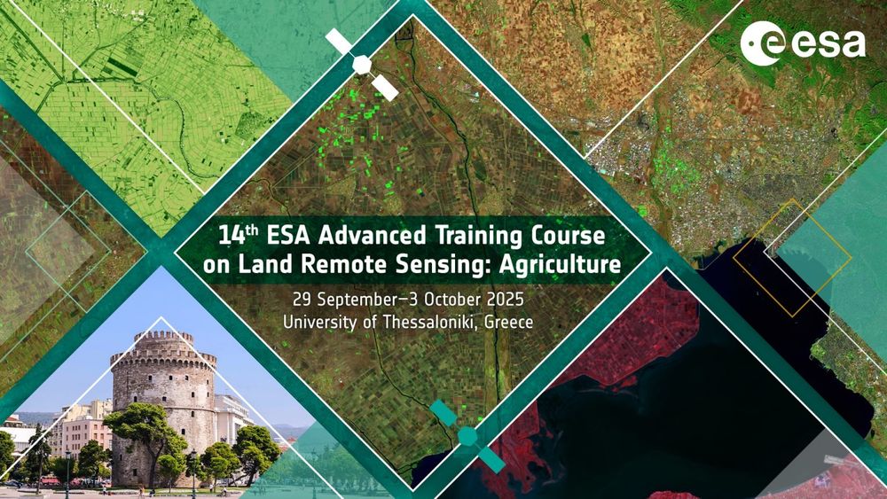
⏳ Reminder: The application deadline for the 14th #ESA Advanced Land #Training course with the focus on #agriculture has been extended to 1st July 2025!
🗓️ 29 Sept. - 3 Oct. 2025
📍 Thessaloniki, Greece
👇 Find out more directly on the course website: landtraining2025.esa.int
#EOchat #GISchat
27.06.2025 14:51
👍 2
🔁 1
💬 0
📌 0

ESA Advanced Land Training Course 2025
The European Space Agency (ESA) is organising an Advanced Training Course on Land Remote Sensing with the focus on Agriculture in collaboration with the University of Thessaloniki. This course is dedi...
‼️ The deadline for applications has been extended to 1st July 2025!
Don't miss out the ESA Land training focusing on EO in Agriculture in Thessaloniki, Greece!
Register here: landtraining2025.esa.int
#EOTrainingAcademy #GISchat #EOchat #GeoSky #EarthObservation #RemoteSensing #Agriculture
16.06.2025 18:42
👍 1
🔁 1
💬 0
📌 0
📢 Last 3 days to apply for #ESA 14th Advanced #Training Course on Land #RemoteSensing with a focus on #Agriculture!
📅 When: 29 September - 3 October 2025
📍 Where: Thessaloniki, Greece
👉 Deadline: 12 June 2025
🔗 More info and registration: landtraining2025.esa.int
#GISchat #EOchat #geosky #eo
09.06.2025 06:53
👍 3
🔁 3
💬 1
📌 1


I have developed a user-friendly interface for using the MMTS-GEE. It is available here: code.earthengine.google.com/64a4db31218a... (you need a GEE account).
You can find it also on GitHub: github.com/palubad/MMTS...
The full-quality poster is available here: storage.mlcdn.com/account_imag...
29.05.2025 08:02
👍 3
🔁 0
💬 0
📌 0

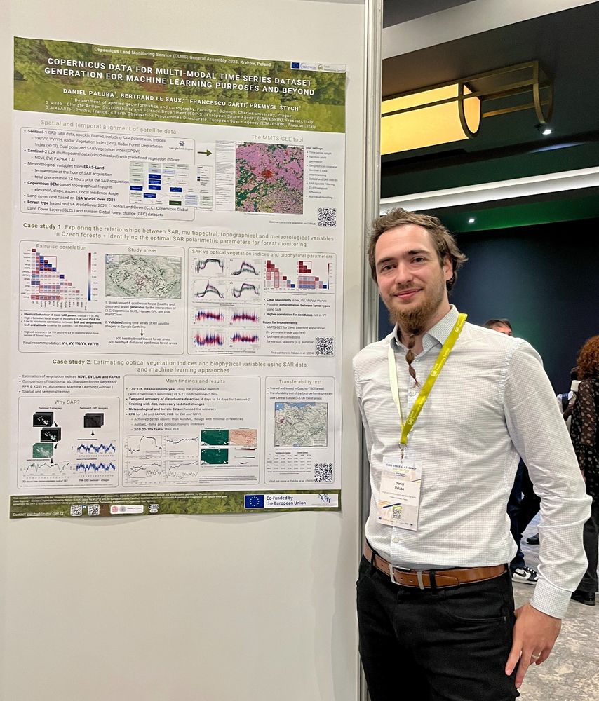
Last week, I participated the #CLMSGA2025 in Kraków, Poland, where I presented the MMTS-GEE tool to generate spatially and temporally aligned SAR, optical, topographic and meteo. data. I also showed two case studies using MMTS-GEE:
1️⃣ doi.org/10.14712/233...
2️⃣ doi.org/10.1080/2096...
#GisChat #GeoSky
29.05.2025 08:02
👍 2
🔁 0
💬 1
📌 0

🌍 Join us for a presentation by Dr. Francesco Sarti from ESA/ESRIN on "Our planet from space: ESA’s satellite missions & education"
📅 Wednesday, 28 May 2025 14:00–15:30
📍 Kampus Hybernská, A.3 Velká zasedací místnost, Hybernská 998/4, Prague,
Register: evening-closet-d98.notion.site/1ff8779ec7b7...
26.05.2025 15:16
👍 1
🔁 1
💬 0
📌 0
@tandfresearch.bsky.social
06.04.2025 08:21
👍 2
🔁 0
💬 0
📌 0
#gischat #geosky
@sciencecharles.bsky.social
02.04.2025 12:28
👍 2
🔁 0
💬 0
📌 0
✅ Achieved temp. resolution of up to 240 measurements/year using SAR-based VIs with 2 S1 satellites in 2021 [soon to be restored with Sentinel-1C]
✅ Early disturbance detection: within 4 days vs 35 days with optical indices
✅ Fine-tuned #XGBoost and #RandomForest regressors outperformed #AutoML
02.04.2025 07:47
👍 0
🔁 0
💬 1
📌 0
👉 Temporally and spatially aligned SAR, DEM-based & meteo. features trained to estimate time series of #NDVI, #EVI, #LAI & #FAPAR
👉 Trained and tested in Czechia for healthy deciduous and coniferous forests, as well as disturbed areas ⏩ transferability tested for the whole Central Europe
02.04.2025 07:47
👍 1
🔁 0
💬 1
📌 0

https://doi.org/10.1080/20964471.2025.2459300


Can we estimate optical vegetation indices and biohpysical parameters for forests using #Sentinel1 #SAR & ancillary data? We tried to answer this in our latest paper in @bigearthdata1.bsky.social With the help of #machinelearning we generated SAR-based NDVI, EVI, LAI & FAPAR
doi.org/10.1080/2096...
02.04.2025 07:47
👍 8
🔁 2
💬 3
📌 1
Great to see it in action. Looks cool!
It reminded me that for larger countries, I should add a selection for smaller administrative units. I will try to implement it soon.
29.03.2025 04:44
👍 1
🔁 0
💬 0
📌 0
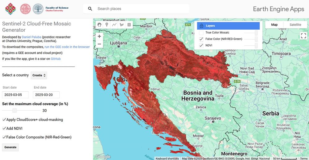
🌍 I have created an interactive #GEE app to generate #Sentinel2 cloud-free mosaics for any country and timeframe, defined by the user.
Generate your mosaics: danielp.users.earthengine.app/view/sentinel2-cloudfree-mosaic-generator
GitHub: github.com/palubad/S2-Mosaic-Generator
#gischat #dataviz
27.03.2025 09:26
👍 17
🔁 4
💬 1
📌 1
Přihlašte se k odběru newsletteru Copernicus Academy CZ - EO4Landscape
Po zadání e-mailové adresy obdržíte potvrzovací e-mail. Pro odběr je nutné potvrdit Vaši registraci kliknutím na zaslaný odkaz.
👉 Sign up for our newsletter here: eo4landscape.natur.cuni.cz/newsletter-2/
The Copernicus Academy CZ newsletter is prepared by the EO4Landscape research team at @sciencecharles.bsky.social Department of Applied Geoinformatics and Cartography, with support from the FPCUP project.
23.03.2025 06:18
👍 2
🔁 0
💬 0
📌 0
🌍 @copernicusland.bsky.social LMS General Assembly 2025 – registration & abstracts open for Krakow (May 20–22)
🚨 Copernicus Emergency Monitoring Service Conference – insights into flood monitoring (April 2–3)
🥦 Zero Hunger Online Course series by @EO College – explore EO’s role in food security
23.03.2025 06:18
👍 0
🔁 0
💬 1
📌 0
💨 WEkEO Workshop on Atmospheric Monitoring – live demos and user experiences (March 24 & 26)
📡 @esa.int ESA Earth Observation Workshop 2025 – hands-on training at ESA Academy in Belgium (July 14–18)
🛰️ DLR/ESA Open PolInSAR Course – deep dive into Polarimetric InSAR techniques (March 28 deadline)
23.03.2025 06:18
👍 0
🔁 0
💬 1
📌 0
What’s inside?
🚀 Advanced Use of Copernicus Browser – an interactive webinar on exploring Copernicus data by the Copernicus Data Space Ecosystem (April 8)
🌲 Remote Sensing of Forests Summer School – UAV, SAR and LiDAR applications at the Czech University of Life Sciences Prague (June 2–6)
23.03.2025 06:18
👍 0
🔁 0
💬 1
📌 0

📰 The March issue of the Copernicus Academy CZ newsletter is here! This edition brings a plenty of Earth Observation opportunities, including online and face-to-face trainings, hands-on workshops and interesting conferences.
Read it here: https://eo4landscape.natur.cuni.cz/wp-admin/admin-ajax.php?action=tnp&na=v&nk=0-0&id=15
While the newsletter is in Czech 🇨🇿, most workshops and events are in English, so don’t miss out any!
What’s inside?
🚀 Advanced Use of Copernicus Browser – an interactive webinar on exploring Copernicus data by the Copernicus Data Space Ecosystem (April 8)
🌲 Remote Sensing of Forests Summer School – UAV, SAR and LiDAR applications at the Czech University of Life Sciences Prague (June 2–6)
💨 WEkEO Workshop on Atmospheric Monitoring – live demos and user experiences (March 24 & 26)
📡 ESA Earth Observation Workshop 2025 – hands-on training at ESA Academy in Belgium (July 14–18)
🛰️ DLR/ESA Open PolInSAR Course – deep dive into Polarimetric InSAR techniques (March 28 deadline)
🌍 Copernicus Land Monitoring Service General Assembly 2025 – registration & abstracts open for Krakow (May 20–22) Copernicus EEA
🚨 Copernicus Emergency Monitoring Service Conference – insights into flood monitoring (April 2–3)
🥦 Zero Hunger Online Course series by EO College – explore EO’s role in food security
💧 NASA ARSET Courses – waterborne diseases & wildfire monitoring using satellite data
📍 Czech Association for Geoinformation Conference – key topics in GIS & Smart Cities (May 5–6, Prague)
👉 Sign up for our newsletter here: https://eo4landscape.natur.cuni.cz/newsletter-2/
The Copernicus Academy CZ newsletter is prepared by the EO4Landscape research team at Faculty of Science, Charles University’s Department of Applied Geoinformatics and Cartography, with support from the FPCUP project.
The March issue of the #CopernicusAcademy CZ #newsletter is here! It brings a plenty of #EarthObservation opportunities: online and face-to-face trainings, workshops and conferences.
Read it here: shorturl.at/NTIUD
While it is in Czech, most events are in English, so don’t miss out any!
#gischat
23.03.2025 06:18
👍 2
🔁 0
💬 1
📌 0
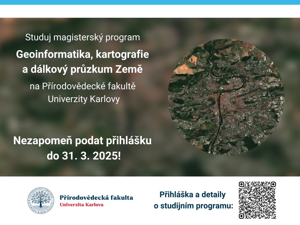
🌍🛰️ Přihlašte se do našeho magisterského studijního programu #Geoinformatika, #kartografie a dálkový průzkum Země!
⏳ Máte posledních 10 dní - do 31. 3. 2025 - na podání přihlášky!
Více o programu: natur.cuni.cz/uchazeci/stu...
#RemoteSensing #EarthObservation #GIS #Cartography
21.03.2025 13:04
👍 0
🔁 0
💬 0
📌 0