

These are the icy mountains of Pluto. It took 9 years to get these magnificent images… and 4.8 billion kilometers.
18.01.2026 19:39
👍 3338
🔁 1090
💬 42
📌 151
These are the icy mountains of Pluto. It took 9 years to get these magnificent images… and 4.8 billion kilometers.

'The scale of the unrest now gripping Iran is the largest since the demonstrations of 2009; some veteran Iran-watchers reckon the protests are the biggest since the overthrow of the shah in 1979' www.economist.com/middle-east-...
For those keeping score, Bellingcat, The New York Times Visual Investigation Team, & Washington Post's Visual Forensic team have all published analysis showing the ICE shooter wasn't in the path of Renee Nicole Good’s vehicle when he shot her, contradicting statements by the President & his cronies

“Seen from the sky, once bustling markets are empty and overgrown with vegetation.“ www.economist.com/interactive/...
A nearly one-week animation for Hurricane Melissa with infrared (IR) imagery on the left and its maximum wind speed (intensity) evolution on the right. The animation briefly pauses at landfall in Jamaica.
IR images extend about 600 km from the center of the storm to illustrate its shape evolution.

What makes Hurricane Melissa so different to other storms?
A terrific piece with stellar graphics pulled together by our special-projects team with help from across the paper @ainsliejstone.bsky.social @fteoldi.bsky.social @eljlees.bsky.social
@josephc.net
www.economist.com/interactive/...

“The offensive has come at an enormous cost: our meta-estimate suggests over 100,000 Russian soldiers have died in the war this year.” The quiescence of Russian society in the face of the meaningless slaughter of their men is horrifying.
The commercial remote sensing industry relies extensively on NASA data from missions like MODIS, VIIRS, and PACE for calibration & atmospheric correction. It’s not just about climate & the environment.

Russia and NATO have the most extensive networks of military and civilian bases in the Arctic. These maps illustrate their ambitions for the region

Great-power competition in the far north puts renewed attention on Svalbard
www.economist.com/interactive/...
“The studies imply estimated [Gaza] life expectancy has fallen by more than 35 years, to ~ half the pre-war figure. In percentage terms…bigger than…during China’s Great Leap Forward; in absolute terms it is similar to the one in the Rwanda genocide” www.economist.com/interactive/...

‘Within just over a week Florida used emergency powers to seize land from Miami-Dade County and build a 3,000-bed prison in the middle of a national preserve.‘
www.economist.com/interactive/...

47% of people think immigration is primarily illegal. There were 4% irregular arrivals in March
New YouGov polling. A monumental failure of our political class to educate, a monumental failure of our media to report fairly, for a generation
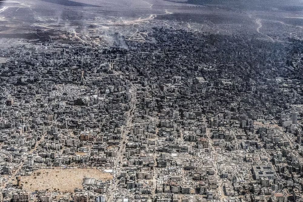
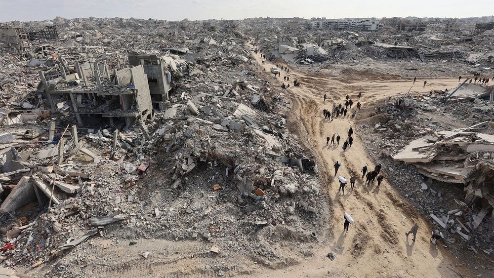
An aerial view of what the Gaza City area looked like this week. Taken from a Jordanian military aircraft, by our colleague Heidi Levine.

Our analysis of data from the front lines in Ukraine suggests Russia is suffering its heaviest losses of the conflict so far. We use satellites to track the fighting: www.economist.com/interactive/...

Driving food insecurity and competition for resources, climate change can indirectly intensify conflict risks. Cornelia Scholz explains how we can analyse trends in climate and conflict data, and understand the risks. www.bellingcat.com/resources/ho...

Iran’s nuclear programme is distributed among several sites, as our map shows. This makes it harder to attack and disrupt https://econ.trib.al/lokRjlR
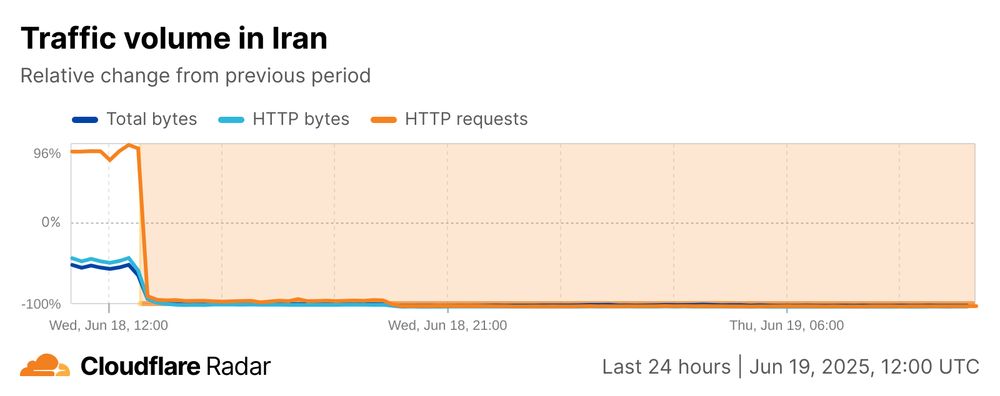
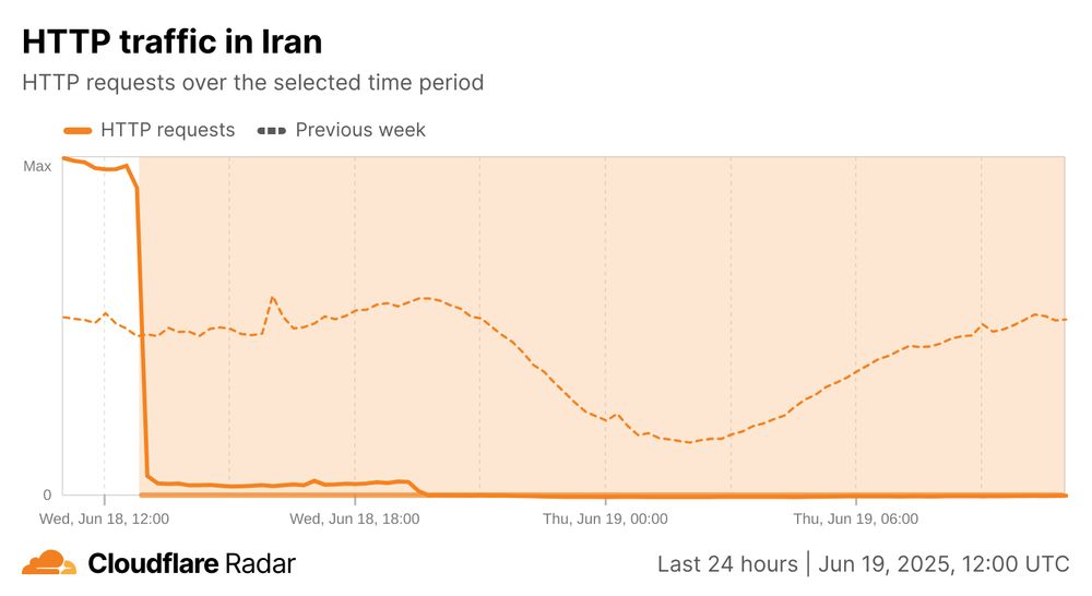
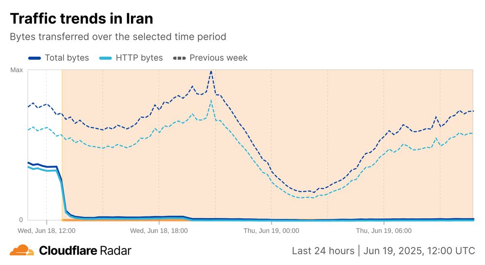
Nearly 24 hours after #Internet connectivity was cut in the country, #Iran remains offline, with the last bits of traffic disappearing around 20:00 last evening.
Follow the latest status at radar.cloudflare.com/traffic/ir?d...

To track the Israel-Iran war, @economist.com, I think uniquely, monitors 208 strategic sites in Iran for abnormal thermal activity. It can be hard to know how much maps of confirmed strikes may miss. We find broad overlap, but not perfect. www.economist.com/interactive/...

Map of Iran indicating possible strikes at military, nuclear and industrial sites.
We now have an updating fires tracker on the page indicating possible strikes at military, nuclear and industrial sites

Today, Ukrainian intelligence launched 117 attack drones from trucks that had been placed near Russian air bases. I tasked several collects this morning via Umbra and my first images have already started processing. What a remarkable success in a well-executed operation.

Western countries have mostly looked away as Myanmar’s struggle for democracy has turned chaotic and violent. China has filled the resulting vacuum to advance its own agenda https://econ.trib.al/Bk2jg6b

China has become the most powerful player in Myanmar’s civil war. To see how, follow an oil-and-gas pipeline through three conflict zones.
www.economist.com/interactive/...
NOAA just announced a long list of datasets that are going away🧪⚒️🌊: www.nesdis.noaa.gov/about/docume...
Download what you need asap and send comments to: ncei.info@noaa.gov

Shakemap by USGS for the M7.7 earthquake in Myanmar on Mar 28, 2025. Shaking expected up to violet. There will be heavy damage.
The USGS already released a shakemap for the M7.7 #earthquake in Myanmar a few minutes ago. This will be devastating. ⚒️🧪
earthquake.usgs.gov/earthquakes/...
The US will no longer worry about civilians getting in the way of their bombs:
www.nytimes.com/live/2025/03...


