

Virtual "Map & Yap" meetup is happening TONIGHT, Feb 26th, at 6pm. Anyone is welcome, we hope to see you there! 🗺️
https://cwm.zoom.us/j/81451882713
26.02.2026 15:44
👍 1
🔁 1
💬 0
📌 1
Virtual "Map & Yap" meetup is happening TONIGHT, Feb 26th, at 6pm. Anyone is welcome, we hope to see you there! 🗺️
https://cwm.zoom.us/j/81451882713
FYI: Dr. Keener will not be present to give his talk about Surveillance Inequality at tonight's meetup. However due to the last minute nature of this change, we will still be meeting to chat all about mapping surveillance in OpenStreetMap.
Dr. Keener & his co-author Dr. Finn will still be […]
Incredibly heartbreaking. He gave @maprva.org a tour just 3 weeks ago, sending his staff home and staying behind so that we could spend just a *little more* time looking around. His joy of the collection was contagious.
Infuriating that we have another pedestrian killed by a car.
RE: https://en.osm.town/@weeklyOSM/115757361079892677
yesterdays.maprva.org was featured in issue 804 of @weeklyOSM !

Close-up of a Sanborn fire insurance map. Edits to the map are visible where new construction was (literally) pasted over old.

A group of people staring at an opened Sanborn fire insurance volume.

A group of people looking at an original panorama of Main St in Richmond from the late 1880s.
Field trip to @thevalentinerva.bsky.social today with @maprva.org to see some amazing historic pictures of Richmond, VA.
They also pulled a Sanborn fire insurance map for us, which was kept up to date into the 80s by pasting pieces of paper with new/removed construction over the old map.
OldinsuranceMaps.net is such an amazing and thoughtful tool. So easy to georeference these maps and look back in time. Do yourself a favor and go poke around.
@maprva.org's Yesterdays project would have been impossible without it. yesterdays.maprva.org
Some armchair Flock hunts on OpenStreetMap -- Gilpin is, in fact, littered with RPD Flock devices. This is 3 within 10 ft of each other! @maprva.org
#RVA

Aerial picture of the flooded James River in Richmond, Virginia. Mayo bridge is in the foreground, Mayo Island is completely flooded save for the roof of an old baseball field.
Flood of 1936 over Mayo Island, including the old ball park.
yesterdays.maprva.org/19340/
#rva @maprva.org

Meme of a gnome staring at computer screen. Top text: born too late to explore the earth, born too soon to explore the galaxy, born just in time to browse the evolving built environment of richmond post civil war
join us yesterdays.maprva.org
Georeference tool has been renamed to **YESTERDAYS**, and we've been squashing bugs left and right.
Explore nearly 30k images, 2.8k of which we've placed on a map. Our collections span from the Civil War to COVID-19 and everything in between.
https://yesterdays.maprva.org

Went cycling on the (recently-opened) Ashland-Henrico portion of the Fall Line Trail outside of Richmond, VA with @maprva.org last weekend.
We took 360 imagery the whole way. If you'd like to see the whole 7 miles from your couch, click below!
RVA area peeps: @maprva.org will be leisurely cycling the new Henrico-Ashland portion of the Fall Line Trail next Saturday Nov 8.
We'd like YOU to join!
Plan is to meet behind the VCC Target ~11a, bike 7 mi to Ashland, eat, look at historic houses, and head back.
DM/reply for more details!
Friendly reminder that our next meetup will be next Wed Oct 29th at Main Library, 6pm. We'll talk cemetery mapping! Including a presentation from Beth Zizzamia of the University of Richmond! In other words, it's going to be a good one 😀 hope to see you there!🎃 👻
Friendly reminder that our next meetup will be next Wed Oct 29th at Main Library, 6pm. We'll talk cemetery mapping! Including a presentation from Beth Zizzamia of the University of Richmond! In other words, it's going to be a good one 😀 hope to see you there!🎃 👻
In fun hyper-local information and mapping, @maprva.org (@trailsta.sh) has mapped the RVA gun hole on @openhistoricalmap.org... and also added a page in @wikidatacommunity.bsky.social.
www.openhistoricalmap.org/node/2140307...
www.wikidata.org/wiki/Q136514...
Our next meetup is TONIGHT at 6pm, and it's VIRTUAL! Can't wait to see you.
https://cwm.zoom.us/j/87542434646

A pumpkin-themed flyer featuring upcoming MapRVA events. It lists a virtual event on Oct 9, in-person meetup on Oct 16, cemetery mapping presentation on the 29th, and a Fall Line Trail field trip on Nov 8th.
MapRVA has a lot in store for October! Visit maprva.org for more details. Hope to see you there 🗺️

We are proud to have our latest project, Georeference Tool, featured in the Church Hill Lookout!
https://www.chlookout.com/p/like-google-street-view-but-for-richmond-history

A map of Richmond, Virginia with hundreds of circles representing where images were taken. One has a popup open showing a house in the East End of Richmond.
What a fantastic first week of our Georeference Tool! We already have over 500 image georeferences across Richmond, and we're working on importing new datasets!
Our map viewer now allows you to sort by date, and overlay Sanborn insurance maps from the 1900s.
Check it out: georeference.maprva.org

Richmond 2025 Bike Map
Big day for me today. I have in my hands the my first published paper map!

"September Events" poster for MapRVA. Lists three events: bus stop mapping at Main Library on Sept 4, Virtual Map & Yap Zoom on Sept 18, and GIS Week Kickoff at University of Richmond on Sept 29.
Lots to look forward to in September! Hope to see you this week at Main Library for some bus stop mapping. Check out our full calendar at maprva.org

Join us this Thursday, Aug 21st for some mapping fun in Carytown. Meet at New York Deli at 6pm!
https://osmcal.org/event/3982/
Our third and final event with PlanRVA will be this Thursday Aug 7 @ 6:30pm. Please click the link below to RSVP and see event details. Please bring a laptop if you'd like to participate in a group mapping sesh! […]
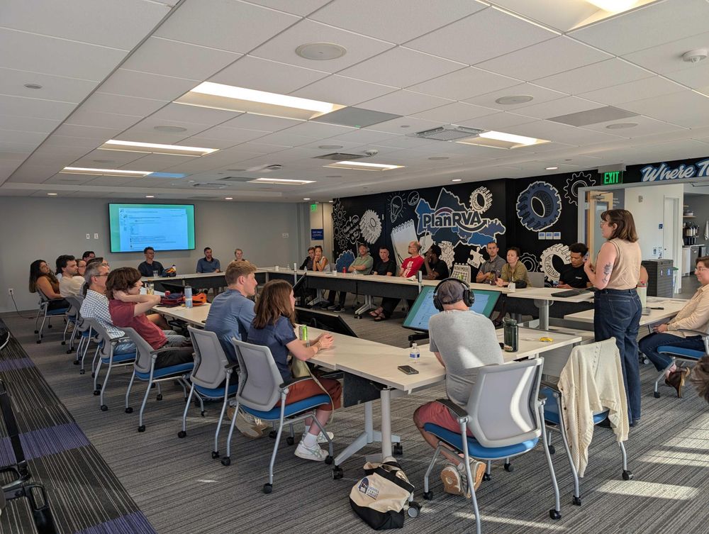
A female speaker addresses an audience seated in a circle around a room. On the opposite side of the room, a TV on the wall shows the speaker's current slide.
Fantastic event tonight at PlanRVA. Thanks to everyone who came out and talked bike/ped infrastructure and the future of planning in RVA. Come join our next event on Aug 7, link below!
https://openstreetmap.app.neoncrm.com/nx/portal/neonevents/events?path=%2Fportal%2Fevents%2F20452
omg @stamen liked our talk 😊 https://stamen.com/stamen-at-state-of-the-map-us-2025/
#introduction
MapRVA is a small group of #mapping & #openstreetmap enthusiasts in Richmond, Virginia #rva
We meet every few weeks.
You can find us on the @OpenStreetMapUS #slack instance in the local-rva channel.