@sonjamaas.bsky.social
12.11.2025 11:29
👍 0
🔁 0
💬 0
📌 0

Map showing points in Utah, North Carolina, Georgia, Jordan, Italy, and Egypt, with great circle paths plotted between them
The {sf} package continues to blow my mind with how easy it is to make maps with #rstats and ggplot (code for that map here gist.github.com/andrewheiss/...)
04.11.2025 13:34
👍 98
🔁 9
💬 2
📌 0
📢 Abstract submission deadline for the World Biodiversity Forum @worldbioforum.bsky.social in Davos is Nov 18!
Join us for our session 'Understanding and caring for Arctic biodiversity together'. All regions, organisms and formats welcome! 🌿🦌🦋
06.11.2025 07:54
👍 9
🔁 2
💬 0
📌 0

Remote sensing for ecology research: The EORC at the GfÖ annual symposium 2025 in Würzburg
Last week, EORC staff participated in and co-organized the Ecological Society of Germany, Austria and Switzerland (GfÖ) Annual Symposium 2025, this year hosted at University of Würzburg. The symposium, attended by more than 600 people, covered a wide range of topics in ecology research with a focus on current challenges in various ecosystems. As it […]
Last week, EORC staff participated in and co-organized the Ecological Society of Germany, Austria and Switzerland (GfÖ) Annual Symposium 2025, this year hosted at University of Würzburg. The symposium, attended by more than 600 people, covered a wide range of topics in ecology research with a focus…
11.09.2025 09:44
👍 11
🔁 3
💬 0
📌 0
Thanks – still not sure if white-to-blue is the optimal colour ramp to visualize snow depth, but in the end I chose blue as the poster's theme colour to convey the coldness of the Arctic winter!
08.09.2025 08:46
👍 1
🔁 0
💬 0
📌 0

Group picture of the staff of University of Würzburg, EORC, attending the GfÖ annual meeting in Würzburg.
Glad to share the time at #gfoe2025 with many of my nice colleagues of @earth-observation.org working at the interface of remote sensing and ecology, and who co-organized the conference.
@jsrieder.bsky.social @msdhill0n.bsky.social
03.09.2025 11:51
👍 9
🔁 2
💬 0
📌 0
Many thanks to everyone involved in this research on whose behalf I am presenting, including
@antoniocastaneda.bsky.social, Elio Rauth, Sebastian Buchelt,
@larissabeumer.bsky.social, @bevanda.bsky.social and others.
@gfoesoc.bsky.social @earth-observation.org
02.09.2025 10:02
👍 3
🔁 0
💬 1
📌 0

A research poster titled "Potential of UAV-derived high-resolution snow depth mapping to advance arctic ecological research on Svalbard"
Snow depth is a crucial variable in high-arctic ecosystems, as it affects soil, plants & wildlife foraging. Yet, spatially-continuous snow depth data is rare.
Stop by poster 38-P1 at #gfoe2025 @uni-wuerzburg.de today to talk about UAV LiDAR snow depth mapping for ecological research on Svalbard!
02.09.2025 08:43
👍 13
🔁 1
💬 2
📌 1
Incredible sight!
31.07.2025 14:13
👍 0
🔁 0
💬 0
📌 0
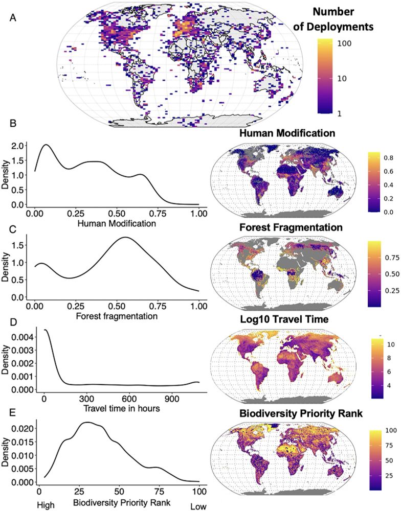
Thrilled to share our new article in @pnas.org highlighting global gaps in where we study animal movement—and outlining the next generation of smart bio-loggers.
👉 Read the full study in PNAS: lnkd.in/exP8NCeZ
1/
30.07.2025 00:02
👍 51
🔁 34
💬 2
📌 0
on an EPSG:4326 grid? :-)
04.07.2025 09:09
👍 3
🔁 1
💬 0
📌 0
If you are interested in learning more about RStoolbox, feel free to read our accompanying #MEE paper: besjournals.onlinelibrary.wiley.com/doi/full/10....
Or visit our docs: bleutner.github.io/RStoolbox/
Feedback, issues and contributions are always welcome! github.com/bleutner/RSt...
27.06.2025 14:00
👍 1
🔁 0
💬 0
📌 0
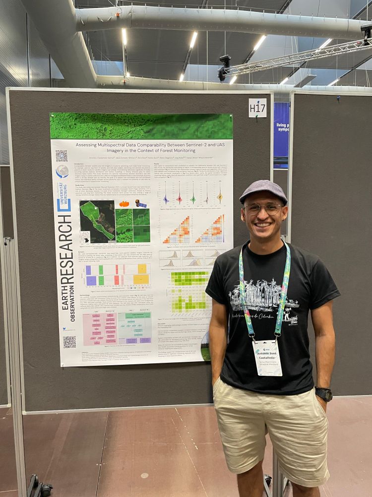
Swing by my poster today at the #LPS25!
Excited to share some of our work at the UAS Team, @earth-observation.org ! We’ve been exploring the comparability between UAV-based datasets and Sentinel-2.
@schwalb-willmann.de @bevanda.bsky.social
27.06.2025 07:16
👍 7
🔁 3
💬 0
📌 0
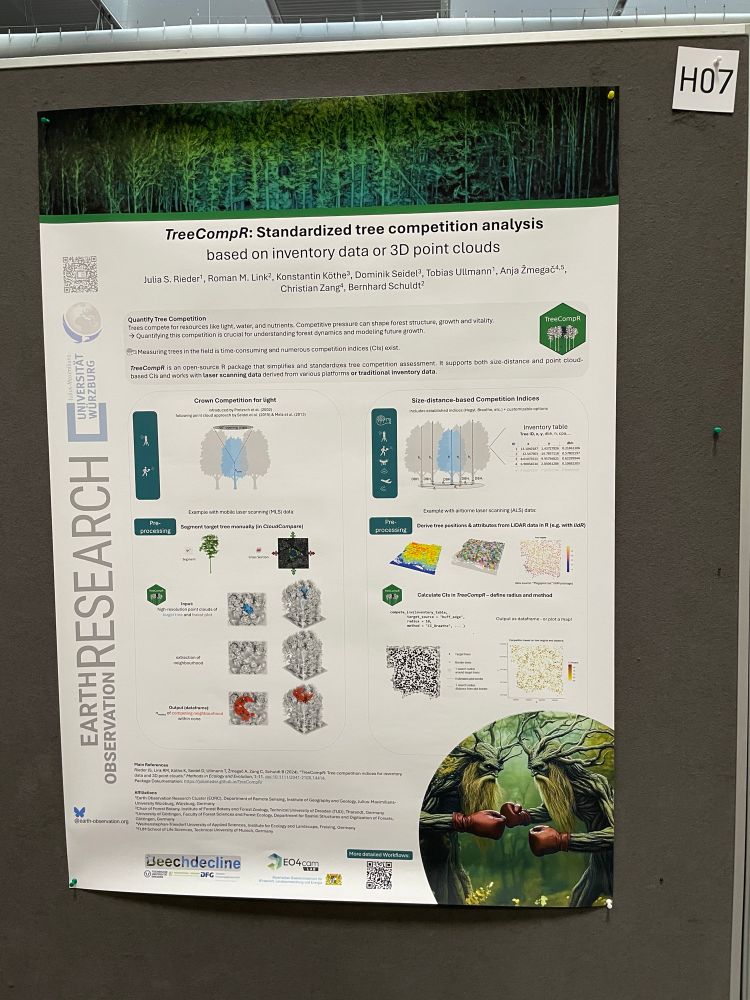
Are you working with LiDAR or inventory data? Visit me at poster H07 at #LPS25 to find out more about our R package, TreeCompR, which provides solutions for quantifying tree competition!
27.06.2025 07:07
👍 21
🔁 8
💬 0
📌 1
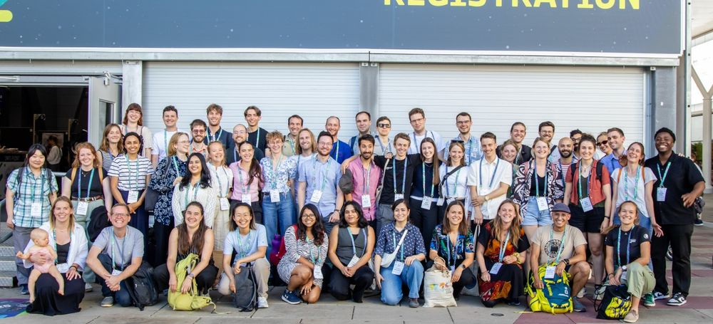
great group picture of our EORC staff and EAGLEs at ESA #LPS25 - a fantastic week with plenty of interesting discussions, talks and posters! #earthobs #eochat #remotesensing
26.06.2025 10:11
👍 11
🔁 4
💬 0
📌 0
Happy about all the interest shown in RStoolbox at #LPS25! Had the chance to discuss the role of R in EO, how R+Python integrate, and what drives programming language preference (e.g. when research communities implement their methods predominantly in one language, creating unique package ecosystems)
26.06.2025 09:23
👍 2
🔁 0
💬 1
📌 0
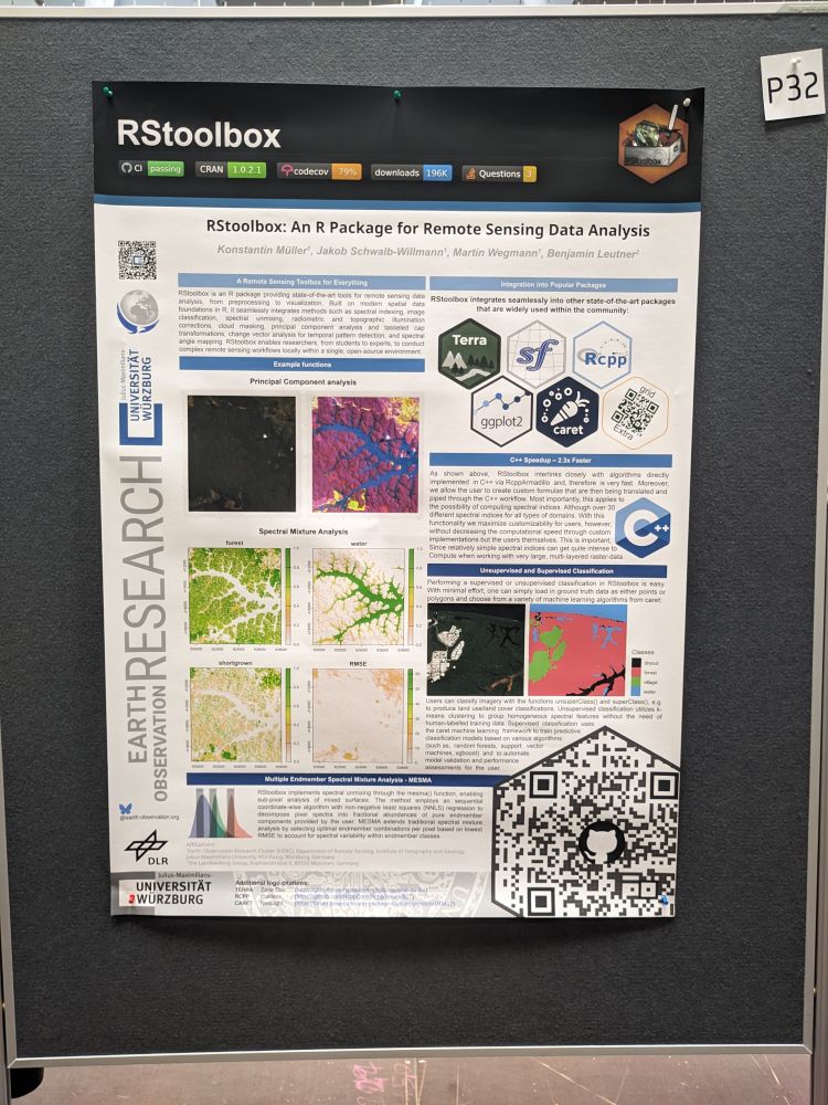
The RStoolbox poster at the ESA LPS25.
RStoolbox, an R package for remote sensing data analysis, is being presented at ESA #LPS25 today by @caipide.bsky.social and myself.
Come to poster P32 to chat about spatial predictive modelling, spectral unmixing, change vector analysis, radiometric correction, cloud masking etc. using R! #rstats
25.06.2025 14:08
👍 26
🔁 7
💬 2
📌 0
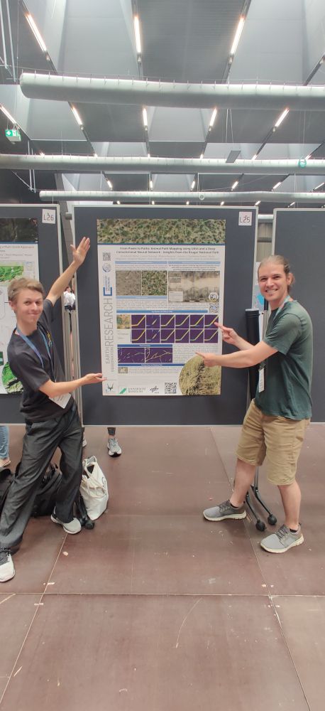
Glad that there has been so much interest in our DL approach on detecting animal paths in UAV RGB data! Thanks to all who made this study possible, incl. Leonie Sonntag, @bevanda.bsky.social, @antoniocastaneda.bsky.social, Martin Wegmann, Ben Wigley, Corli Coetsee, Doris Klein & Stefan Dech #LPS25
25.06.2025 09:22
👍 4
🔁 1
💬 0
📌 0
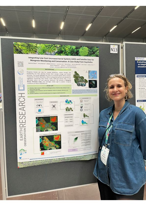
Catch me & @annabischof.bsky.social at tonight’s #LPS25 poster session in Vienna! We're presenting our work with Nature Seychelles & @earth-observation.org on RGB drones for mangrove monitoring. Marlene Bauer can't join, but her input was key. Excited to connect! #UAV #Ecology #RemoteSensing
24.06.2025 12:58
👍 7
🔁 2
💬 1
📌 0
Having a blast at ESA's #LPS25 with @schwalb-willmann.de and a nice poster about animal paths 🐘 Swing by!
24.06.2025 14:35
👍 20
🔁 4
💬 1
📌 0
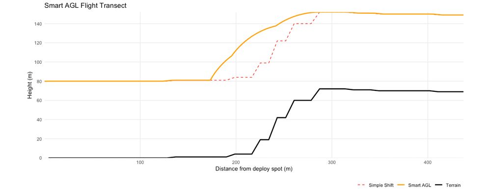
Planning a hyperspectral drone mission in steep terrain, I ran into the usual issue: flying too close to the slope due to poor AGL handling. I built SMARTAGL, an R tool that creates terrain-aware flight lines with constant AGL. Open-source & field-tested. (github.com/ajcastanedag...)
21.05.2025 13:34
👍 10
🔁 4
💬 0
📌 1
AnySat has been accepted as a ✨ highlight at #CVPR2025! See you in Nashville 🎉
We’ll also be presenting this work at:
📍 @egu.eu on 02/04 in Vienna
📍 @esa.int / NASA Workshop on Foundation Models on 05/04 in Rome
30.04.2025 13:49
👍 13
🔁 2
💬 0
📌 1
⚠️ Nearly 40 billion (39,820,373,479) new embeddings of Major TOM Copernicus data now released!
More details: www.linkedin.com/feed/update/...
28.04.2025 05:31
👍 11
🔁 4
💬 0
📌 0


