Author of the Rivers of London Series
Award winning Frameshift Designer @ TULP interactive
https://tulpinteractive.com https://timebender.io
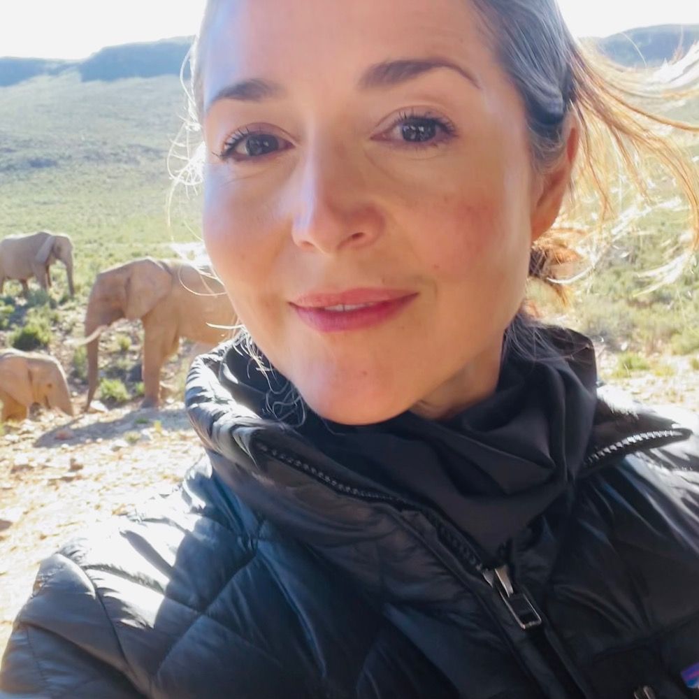
@cnrs-insu.bsky.social researcher at @climatecerege.bsky.social.
Using biomarkers to study climate, ocean, and environment of the past.
@icta-uab.bsky.social alumna.
ORCID: https://orcid.org/0000-0002-3047-6064
🇫🇷 -> 🇪🇸 -> 🇫🇷
Devon based dad, outdoor enthusiast, morris squire, spatial analyst, fan of classic pubs, web publisher & professional meteorologist | personal views.
🌦️ Physicist (research on aerosols, atmosphere & climate, developing satellite algorithms, occasionally some data visualization)
🚲 Excited about bikes & everyday cycling (Kuopion polkijat board member)
🌍 Kuopio, Finland
Posts both in English and Finnish.
Yes it's me from twitter and @bigbookofr.com!
#dataBS #RStats
#rstats | #energy | #climate | #carbonmanagement | #sustainability | #ESG
https://karbonkounsel.org/
Freelance Data Visualization Specialist and Data Analyst. 📊 Book nerd📚. Always seeking new insights and knowledge💡Available for Projects.
https://deepalikank.in/
Data visualization designer
krisztinaszucs.com
Professor Emeritus of geography & environmental studies, Saint Mary's University, Canada.
Interested in mapping, urban planning, transportation, time use, Nova Scotia
#geography #location #maps #transportation #urban
Associate Professor @UTKnoxville | Amazon Scholar | Creator of #geemap & #leafmap | Talk about #Geospatial #GeoPython #DataViz #GIS #FOSS #EarthEngine
Researcher. Cities, urban morphology, human geography & spatial data science. Open source software developer. #python #cities #open_science
https://martinfleischmann.net
#Urbanismo, Política y Filosofía | Maestría en Planificación y Políticas Urbanas.
https://substack.com/@fernandomaidana
(Mis opiniones son personales)
Forest Fire Research Scientist with Canadian Forest Service 🔥🌲🌳 and the WildFireSat mission 🚀🛰 📡 | Advancing how we use satellites to monitor fires and their impacts | Woman in Remote Sensing | Mother in Science 💻👩💻👩🔬🧪 | she/hers | celiac | 📚🎵🎶👟☕️ | 🇨🇦🇺🇸
Research Faculty at Michigan State University. Geodesy, Tectonics, and Glaciers. All opinions my own.
Collaborative Innovation @IGNFrance.bsky.social 🇫🇷 | Chair of Commission 4 @EuroSDR 🇪🇺 | 🌍🗺️🛰️ #Innovation #OpenData #DataValuation #Commons | ♀️=♂️
data scientist in toronto / maps and dataviz / almost useless trivia knowledge
https://ivabrunec.github.io/
#LFC fan, from Plymouth, lives in Corfe Mullen Dorset, husband, father, grandad, brother, son.
Climate scientist at DMI, Greenland, Antarctica, polar regions in general.
Dipping a toe in yet another social media site. Mostly on mastodon though @ruth_mottram@fediscience.org
Blogging at sternaparadisaea.net
I like collating data,
and getting thoughts in the brain.
All for Public data, Aotearoa New Zealand, and informed communities. #openData #NewZealand #Aotearoa #rstats. He/him.
He tangata tiriti ahau
Pro Genealogist & Scientist at www.khronicle.co.uk, #Genealogy Expert for Time Team. Oxford D.Phil.(SysBio), Fiend for #maps & #research methods. Big hair, big heels, weakness for cake.She/her.
Blog: www.parchmentrustler.com
Demographics | Geospatial | Data Science | Open Source
Climate Scientist -Earth -Water -Data.
PhD, PG
https://scholar.google.co.uk/citations?hl=en&pli=1&user=aEgv38gAAAAJ
Associate Prof of Geography | @UofSouthAlabama | Climate Change | Agriculture | Viticulture/Wine | GIS | Certified Spin 🚴 Instructor | Tacos | Not necessarily in that order
Researcher @CIBIO_InBIO interested in #climatechange #biodiversity #spatialecology #remotesensing
Strong addiction to maps🤷♂️
William C. Wonders Map Collection, University of Alberta Library. Curation by Wyman Laliberté (he/him) (settler on Treaty 6 land).
WCW Map Collection on Internet Archive
https://archive.org/details/wcw
#spatial #maps #cartography #gis #qgis
UW Madison Geography, opinions are mine. Geomorphology, soils, dunes, loess, in the Midwest, Great Plains, northern China. He/him. Living on Ho-Chunk lands.
TUDelft BK-Urbanism community of practice that aims to empower students, researchers, and practitioners to use open-source software and open science practices to answer urban questions effectively and with confidence | #rstats #urbanism | rbanism.org
NFLDer in the UK. Lecturer in GIS and Spatial Analysis - U. Sheffield. Digital media/ regional graphics editor for ‘Regional Studies, Regional Science’. Urban econ, data, spatial stats & open science 🌎🗺️
Tropical geek & hobbit
🇧🇷 data journalist | #rstats #rspatial #ddj #data | 🎲 📊 🗺️
I cover democracy, corruption, environmental crime and inequality.
📍São Paulo / Brasília
🏆2023 SEJ & OPC |🥈Pulitzer finalist
https://linktr.ee/ceciliadolago
🛰️🌲🔥 Researcher at Oregon State University / Earth observation and fire / open source geospatial / Python / Earth Engine
aazuspan.dev
Map nerd and data analyst.
https://www.mel-likes-maps.com/
Product Owner Digital Service GIS / Senior Architect GIS & software at SBB (Swiss Federal Railways) with love for beautiful maps, vintage computers & most importantly the demoscene (Unlock/Padua^Vantage). Founding member & president of @echtzeitkultur
#AllDataIsSpatial #DataIsPlural #KiwiInColorado | Spatial Data Scientist / Researcher | Sharing (Mainly) GIS, Spatial and Geology 'Stuff' | Personal Account, Not Specifically Related To My Employer
Editor at Environment & Planning, B and expat at the University of Bristol. Code with pysal and geopandas. Stats, Cities, and People. Catch up with me at http://ljwolf.org
Geography/GIS educator FRCGS FRGS. Climate SLR. #Dal #SMU #QE2PlatMedal. Semple GeogEd Award. Apoplectic-adorable. Shot 67. Book addict (socialtechfuture) CBCIdeas. Sci-fi. Old movies. WHU COYI. Parkinsons sucks | michaeljfox.org | Mi’kma’ki (Nova Scotia)
Associate Professor. GIScience, Movement Analytics and hiking/walking photos.
Adorable little academic journal. We publish on geographical methods, spatial and urban analytics + innovative applications. Editor: @rsfrankl.bsky.social
https://onlinelibrary.wiley.com/journal/15384632
Picterra provides sustainability leaders with a Mission Control for Environmental Intelligence.
Our GeoAI platform transforms satellite and drone imagery into continuous, verifiable insights across land, supply chains, and ecosystems.
➡️ picterra.ai
🗺🇳🇿🇨🇦🏔 NZ-based cartographer, actually now Canada-based. Blender, QGIS, ArcGIS Pro, Illustrator. Partial to a good mountain.
southarrowmaps.co.nz
Climate data
Politics
Drone imagery.
InSAR
#climate #drone #geo #brazil #oil #polynesiancanoe #vaa #canoe
🇧🇷
MAGAts are not welcomed here.
Journaliste - Enquête, traitement de données, analyse spatiale et cartographie - Nantes
(Datajournalism, geography & map design)
https://leplan.studio
Academic: Professor at RMIT University, GIScience, spatial algorithms, AI, and databases, ontologies http://gkl.rmit.melbourne
Author: GIS 3e http://gisacp.duckham.org
Me: gender equity, wheelchair user, food, new music
putting R in production @ricochet.rs
doing spatial stats @ Esri
blog: josiah.rs
Research ecologist. Author of the {elevatr} #rstats package. Still a tired parent. Raised in KC! Opinions and posts here are all my own. he/him.
#lakes #limnology #rstats #ecology #openscience #geospatial #datascience
Geospatial Intelligence & analytics professional | International Security & Defence | Retired basketball nerd
🇳🇿 🗺️ 🛰️ 🏀 📊 👨💻 🌏 🥝
stay at home data scientist—engineer, hacker, baller—reading & talkin' about politics, open source, technology
currently working on maps, energy and architecture stuff
GIS | Geospatial health | Spatial epidemiology |
| Based @itmantwerp.bsky.social | Funded by @fwovlaanderen.bsky.social | Visiting Scientist @ KEMRI-Wellcome Trust Research Programme | https://www.petermacharia.com/
I like maps, GIS, data visualization, graphic design, hiking, writing, and hanging out in nature. I wrote a book, GIS for Dummies (2nd Edition).
Official Bsky Account for WomenInGIS.org
Chercheure/Researcher - afropéenne
#géographie #cartographie #critique #flowmaps
Univ. Gustave Eiffel
associée UMR Géographie-cites.
enseigne Univ. Panthéon Sorbonne Paris1 & EHESS
https://cv.hal.science/francoise-bahoken
scientist, riverscape research, river enthusiast, big family business man
Enseignant-chercheur en géomatique, gommettes et flèches de nord. Univ. Toulouse-2 Le Mirail Jean Jaurès.
University teacher and researcher about geomatics and cartography semiotics, Toulouse, France.
Researcher Gustave Eiffel University, Stats, Data, Maps and Lego !
Economic geographer.
Assistant Professor, Cambridge University.
I research how digital capitalism transforms markets, cities, and inequalities.
https://jmigozzi.github.io
French lecturer in agronomy with teaching and research activities focused on soil sciences and remote sensing for crop monitoring.
Author of "Memo Visuel d'Agronomie", a book of agricultural data visualization.
https://www.broadlyepi.com/
At Broadly Epi, we specialize in innovative public health solutions through expert consultation and data-driven strategies. Our team of experts work to advance health equity, and help the next generation of public health heroes!
(they/them) Assoc Prof of Geography at Eastern Washington University | GIS, fire history, and teaching are my jam! Follow along on Instagram too @DendroGIS 🌲🔥🗺️🖖
👩🏫 Prof Statistics at KAUST
📚 Author Geospatial Health Data http://bit.ly/bookgeo & Spatial Statistics for Data Science http://bit.ly/bookspatial
#rstats #rspatial #geohealth #HBTransform 🚢🐧
🌐 https://www.paulamoraga.com/
GIS |Remote Sensing | Spatial Data Analytics | #GeospatialEnthusiast
DPhil Researcher in Geography and the Environment @oxfordgeography.bsky.social @tsuoxford.bsky.social | human mobility, climate adaptation, inequality, geographic data science
Personal website: https://shivyucel.github.io
Enjoys creating interactive data visualizations, with a particular passion for map-based projects. 🗺️ Living in Leuven, Belgium 🇧🇪
Climate Impact Modelling @ Repath 🐝 Past research at DLR & consulting for World Bank 🌐 Earth Observation | GIS 🗺️ | Climate Risk 🔥
📍 Ulm, Germany
All things modern GIS. https://forrest.nyc/
-Mapping the world- Dr. in Physical Geography | environmental health - bioclimatology - geography. RC Researcher from 🇩🇪 at @mbgcsic.bsky.social @csic.es in 🇪🇸 #rstats #dataviz
Secretary of the @aeclim.org
📍Galicia
ℹ️ https://dominicroye.github.io
Mapas para entender un poco mejor el mundo // Maps to understand the world a little better
📧 Newsletter (🇪🇸): newsletter.mapasmilhaud.com
📧 Newsletter (🇬🇧): www.cartographerstale.com
🗺 Mapas / maps: mapasmilhaud.com
👋🏻 I'm Kate ᵉᵃᵗᵉʳ ᵒᶠ ᵖᵒᵗᵃᵗᵒᵉˢ ᵃⁿᵈ ᵐᵃᵏᵉʳ ᵒᶠ ᵐᵃᵖˢ
🌐 I make #geospatial & #GIS (more) fun by sharing #mappymeme s & #maptastic themes. #GISchat. ᵛᶦᵉʷˢᵐᶦⁿᵉ
http://linktr.ee/pokateo_maps
I paint the world with #rstats and teach you how to unleash your inner #map artist. Join my map adventures and tutorials now:
https://youtube.com/@milos-makes-maps
Educational and informative word maps.
Scroll Down & Get More Knowledge.
A. Nicolas. Cartographe/géomaticien. #SIG #HautesAlpes #CNRSÉditions #ToponymieRomantique #QuizzTown #PosterCarto 🌍🍷🗺
www.le-cartographe.net
Cartography is my passion & profession. Author of CARTOGRAPHY. & THEMATIC MAPPING. Maps+drums+beer+snowboards+footy+politics+sarcasm. 🇬🇧 in 🇺🇸 Views mine. links.esri.com/mappyhour
Dataviz designer, psychiatrist, PhD
https://karaman.is
Cartographer at Woodwell Climate Research Center | previously National Geographic
www.shintanimaps.com
she/her
Front-end cartographer. Research Engineer in Geographic Information Science at CNRS & UAR RIATE. Author of Mad Maps (2019) and Practical Handbook of Thematic Cartography (2020). Observablehq ambassador.
See https://neocartocnrs.observablehq.cloud/cv/
Graphics Reporter with The Wall Street Journal
on Lenni-Lenape land
a cobra vai fumar
https://churchillgeo.com/
Computational geographer. Associate Professor at AMU, Poznan, Poland. Co-author of http://r.geocompx.org, http://py.geocompx.org, and http://tmap.geocompx.org books. #rstats #rspatial #geocompx
https://jakubnowosad.com/
smitten with #rstats · associate prof · political economy · the #rayverse's number one fan
M. Sc in Water Resources💧 | Eng in Structures Construction, Civil Engineering Hydraulics 🏗️ | Water Allocation - Quality Modelling 🌡️ | Data Visualization ✨| GIS 🌐 | R 📊 | Python 🐍
Powerpoint by day, #ggplot2 by night. Here for dataviz and #rstats content and rants about football. 📊⚽️
Based in Cologne, Germany.
Geographer + accidental cartographer. Posting about geography, maps & more.
https://geoviews.net/
Cartography • Geo-visualization • Geo-Scientist • Esri
Keynote speaker • Rock climber • ITMF • behance.net/sarahbellmaps
Data Visualisation Manager at a health think tank 👩💻 Mostly talk about data, #dataviz, #opendata, #maps, #python and #data4good 📈 Into cycling, yoga, sourdough, puns and more. Views my own.
Also active on Mastodon + Linkedin
🗺️ Cartographe indépendante 🗺️ gsutton.fr freelance #cartographer | toujours une carte en préparation | #Arctique & #climat | @artisanscartos.bsky.social | Santé mentale & TPB
GIS and cartography @EU_eurostat (previously @ignfrance.bsky.social), geographical information, maps, orienteering, bike, nature, Europe, Luxembourg, Marseille, Haut-Doubs
https://jgaffuri.github.io/
cartographer of things
https://andywoodruff.com/
👩🏻💻🗺☀️she/her | geospatial data analysis, nature-positive science, and cartography at Conservation International | Tar Heel 💙 🐏 | views my own
Information Management Officer at UNHCR specialized in #DataViz and #maps. Love #rstats stuff, especially making charts with #ggplot2.
Cartography and data-viz enthusiast. “Hobby-etymologist”. 🇪🇺 Europhile of multiple identities 🇷🇴/🇭🇺 |✸☽︎|. Immigrant 🇫🇷. Was an architect once.
Obsessed with data graphics. I design high‑stakes charts.
Founder, Visionary Press • CHARTOGRAPHY weekly
Talks • workshops • consulting → infowetrust.com
Exploring the overlap of science, art, data and randomness.
Building geospatial software · data narratives · creative coding
In my previous life I was an archaeologist · GZ
Geospatial Communicator.
Data + Stories for @developmentseed.org
@osmus.bsky.social Board Member
Hiking shenanigans. Desert dweller.
Data Visualization. Ex-Planet & NASA Earth Observatory. Blue Marble, Earth at Night, color, cartography, occasionally skewed views of Earth. Looking for a job.
Science. Data. Journalism. Maps. Teach: @ucscscicomm.bsky.social. Ex: BuzzFeed News, berkeleyjournalism.bsky.social, @newscientist.com, @nature.com, @science.org.
https://www.peteraldhous.com/
Climate and graphics at @nytimes.com
Email me and check my work: harry.stevens@nytimes.com
Cartographer. Map of the Week - https://mapoftheweek.substack.com . Fake singer songwriter (now on Spotify, Apple, Amazon and others) https://doug-greenfield.pixpa.com
Product Manager at Esri | Interests #GIS, #HealthGIS, #Maps, #DataViz
💼 Co-lead data & visualizations @spiegel.de
🗺️ Blogging about maps at letsmakeamap.com
#dataviz #ddj #maps #rstats